IMAGES TAKEN NEAR TO
Rylandes Court, SOUTHAMPTON, SO16 5DH
Introduction
This page details the photographs taken nearby to Rylandes Court, SO16 5DH by members of the Geograph project.
The Geograph project started in 2005 with the aim of publishing, organising and preserving representative images for every square kilometre of Great Britain, Ireland and the Isle of Man.

There are currently over 7.5m images from over14,400 individuals and you can help contribute to the project by visiting https://www.geograph.org.uk
Image Map
Images are licensed for reuse under creativecommons.org/licenses/by-sa/2.0
Notes
- Clicking on the map will re-center to the selected point.
- The higher the marker number, the further away the image location is from the centre of the postcode.
Image Listing (146 Images Found)
Images are licensed for reuse under creativecommons.org/licenses/by-sa/2.0
Image
Details
Distance
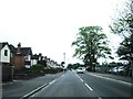
2
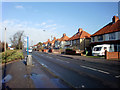
Lancaster Road, Maybush
Viewed from Romsey Road
Image: © Alex McGregor
Taken: 16 Mar 2010
0.10 miles
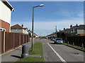
5
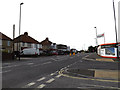
A3057 Romsey Road, Shirley
Looking towards Rownhams Road & Wimpson Lane at the former Ordnance Survey Headquarters
Image: © Geographer
Taken: 27 Jun 2014
0.13 miles
6
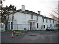
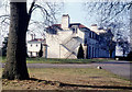
Maybush: Crabwood House
Crabwood House is now in the grounds of the Ordnance Survey's headquarters site, has been in use as one of their offices, but was once a country residence. It is Grade II listed and Southampton City Council's Historic Environment Record of Listed Buildings describes it thus:
"Early C19. Two storeys stuccoed. Flat pitched slate roof with overhanging eaves. Two sashes and one blank. Central Doric columned porch with triglyph frieze and round-headed fanlight. Garden front has canted bay windows. Mid C19 matching wing of slightly lower elevation with 4 sashes. Victorian wood and glass gabled conservatory at rear."
In the current plans to redevelop the whole site the house would be kept and converted back into dwellings.
To give an indication of previous families who inhabited the house, the following were resident on the night that the 1881 Census was undertaken:
Edward St. J. GRIFFITHS, head of the household, married, aged 46, born in France (a British Subject), a Lieutenant Colonel on the Army List (retired),
Georgina F. GRIFFITHS, his wife, aged 34, born in Ireland,
Georgina LARCOUR, his mother in law, a widow, aged 66, born in Spain, (a British Subject), a Lady (a widow of a Lord),
Maud E.G. GRIFFITHS, his daughter, aged 6, place of birth not recorded,
Philip F. GRIFFITHS, his son, aged 4, place of birth not recorded,
Gerald W.L. GRIFFITHS, his son, aged 1, born in Millbrook, Hampshire,
Fanny EMMS, a servant, unmarried, aged 31, born in Nighton, Wiltshire, a cook,
Hannah JONES, a servant, unmaried, aged 25, born in Bentley, Stafford, a parlour maid,
Catherine A. GIBBS, a servant, unmarried, aged 23, born in Mosterton, Dorset, a housemaid,
Catherine JONES, a servant, unmarried, aged 29, born in Radnorshire, Wales (exact place of birth not known), a nurse,
Louisa BROWN, a servant, unmarried, aged 18, born in London, a nursemaid.
Image: © Nigel Cox
Taken: 17 Feb 2010
0.13 miles
7
Compass House
Next to the Ordnance Survey HQ at Maybush, Southampton, the building is used by HM customs and excise amongst others
Image: © Paul Gillett
Taken: 17 Feb 2010
0.14 miles
8
Bus Stop outside Ordnance Survey Office, Southampton
Taken on the occasion of the First Geograph Conference.
Image: © Christine Matthews
Taken: 17 Feb 2010
0.14 miles
10
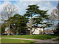
Crabwood House
Grade 2 listed building in the grounds of the former Ordnance Survey HQ
Image: © Alexander P Kapp
Taken: 18 Jan 2011
0.14 miles