IMAGES TAKEN NEAR TO
Percy Road, SOUTHAMPTON, SO16 4LP
Introduction
This page details the photographs taken nearby to Percy Road, SO16 4LP by members of the Geograph project.
The Geograph project started in 2005 with the aim of publishing, organising and preserving representative images for every square kilometre of Great Britain, Ireland and the Isle of Man.

There are currently over 7.5m images from over14,400 individuals and you can help contribute to the project by visiting https://www.geograph.org.uk
Image Map
Images are licensed for reuse under creativecommons.org/licenses/by-sa/2.0
Notes
- Clicking on the map will re-center to the selected point.
- The higher the marker number, the further away the image location is from the centre of the postcode.
Image Listing (44 Images Found)
Images are licensed for reuse under creativecommons.org/licenses/by-sa/2.0
Image
Details
Distance
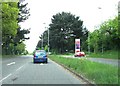
1
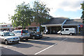
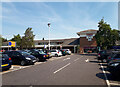
Tebourba Way approaches entrance to Tesco supermarket
The cars on the right are waiting to enter the supermarket access.
Image: © Stuart Logan
Taken: 7 May 2012
0.08 miles
3
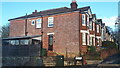
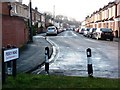
House on the corner of Percy Road
The land slopes quite steeply here, as seen by the retaining wall along Percy Road.
Image: © David Martin
Taken: 14 Nov 2023
0.10 miles
4
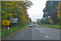
A35 Tebourba Way
Heading west towards Totton.
Image: © Robin Webster
Taken: 13 Nov 2022
0.14 miles
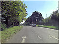
6
Percy Road, blocked off to stop 'rat running' from Romsey Road
Image: © Christine Johnstone
Taken: 17 Feb 2010
0.16 miles
7
King Edward Avenue, Southampton
Viewed across Romsey Road.
Image: © Jaggery
Taken: 16 Nov 2013
0.17 miles
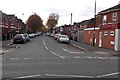
10
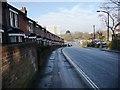
Terraced houses drop down Romsey Road towards the A35.
Image: © Christine Johnstone
Taken: 17 Feb 2010
0.19 miles