IMAGES TAKEN NEAR TO
Broughton Close, SOUTHAMPTON, SO16 4FE
Introduction
This page details the photographs taken nearby to Broughton Close, SO16 4FE by members of the Geograph project.
The Geograph project started in 2005 with the aim of publishing, organising and preserving representative images for every square kilometre of Great Britain, Ireland and the Isle of Man.

There are currently over 7.5m images from over14,400 individuals and you can help contribute to the project by visiting https://www.geograph.org.uk
Image Map
Images are licensed for reuse under creativecommons.org/licenses/by-sa/2.0
Notes
- Clicking on the map will re-center to the selected point.
- The higher the marker number, the further away the image location is from the centre of the postcode.
Image Listing (60 Images Found)
Images are licensed for reuse under creativecommons.org/licenses/by-sa/2.0
Image
Details
Distance
1
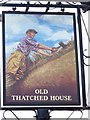
Sign for the Old Thatched House
An excellent pictorial sign.
Image: © Maigheach-gheal
Taken: 20 Jun 2008
0.03 miles
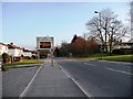
3
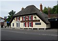
Old Thatched House, Southampton
The Old Thatched House has a prominent position at the top of Shirley High Street on the junction of the A35 and Romsey Road.
Image: © Maigheach-gheal
Taken: 20 Jun 2008
0.04 miles
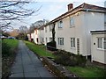
5
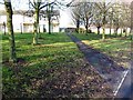
Path from Romsey Road to Maybush Court
Image: © Christine Johnstone
Taken: 17 Feb 2010
0.05 miles
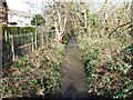
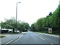
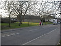
7
No reported incidents on Romsey Road
Image: © Christine Johnstone
Taken: 17 Feb 2010
0.07 miles
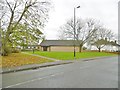
9
Old Shirley, Kingdom Hall
On Romsey Road. http://www.discoversouthampton.co.uk/directory.aspx?id=797
Image: © Mike Faherty
Taken: 17 Feb 2010
0.07 miles
10
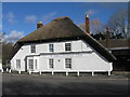
Converted pub, The Old Thatched House
Image: © Alex McGregor
Taken: 7 Feb 2014
0.07 miles