IMAGES TAKEN NEAR TO
Regents Park Road, SOUTHAMPTON, SO15 8TL
Introduction
This page details the photographs taken nearby to Regents Park Road, SO15 8TL by members of the Geograph project.
The Geograph project started in 2005 with the aim of publishing, organising and preserving representative images for every square kilometre of Great Britain, Ireland and the Isle of Man.

There are currently over 7.5m images from over14,400 individuals and you can help contribute to the project by visiting https://www.geograph.org.uk
Image Map
Images are licensed for reuse under creativecommons.org/licenses/by-sa/2.0
Notes
- Clicking on the map will re-center to the selected point.
- The higher the marker number, the further away the image location is from the centre of the postcode.
Image Listing (21 Images Found)
Images are licensed for reuse under creativecommons.org/licenses/by-sa/2.0
Image
Details
Distance
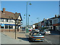
1
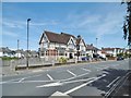
Millbrook, Regents Park
Brewer's Tudor-style public house on Regent's Park Road. Only one room was in use at my visit: a small corner room with back bar, drinking area left and front, background music, TV, games machines & garden. Cask ale on offer: Wadworth 6X.
Image: © Mike Faherty
Taken: 7 Jul 2017
0.12 miles
2
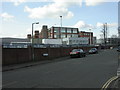
Shirley, tobacco factory
British American Tobacco, as seen from Waterhouse Lane; the main entrance is on Waterhouse Way. http://www.telegraph.co.uk/finance/2788851/Tobacco-and-health-The-smoking-gun.html
Image: © Mike Faherty
Taken: 2 Mar 2010
0.13 miles
3
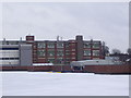
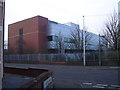
Old tobacco factory building in Millbrook
The imagine was taken from the top level of the nearby multi-storey car park. On the right the original factory building opened in 1926 can be seen with part of the newer factory on the left, opened in 1993. The factories were closed in 2006 when cigarette production was transferred abroad. Both buildings are now scheduled for demolition in the near future. During the 2nd World War the old factory was used for the production of the Spitfire fuel tank.
Image: © peter clayton
Taken: 6 Jan 2010
0.13 miles
4
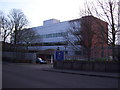
Entrance to British American Tobacco Research and Development Centre on Waterhouse Way
The R&D Centre is situated at the northern end of the BAT site in Millbrook which includes the former cigarette factory; cigarette production there ceased in 2006.
Image: © peter clayton
Taken: 29 Dec 2008
0.15 miles
5
British American Tobacco Research and Development Centre in Millbrook
from the junction of Waterhouse Lane and English Road
Image: © peter clayton
Taken: 29 Dec 2008
0.17 miles
6
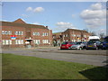
Freemantle, TA centre
Blighmont TA Centre, on Millbrook Road; HQ of various units, including http://www.tanearyou.org.uk/unitdetails.php?id=38
Image: © Mike Faherty
Taken: 2 Mar 2010
0.18 miles
7
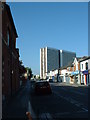
Church Street, Shirley, Southampton
Church Street, Shirley, viewed from Shirley High Street. The shot is dominated by the 1960s block of flats called Shirley Towers.
Image: © GaryReggae
Taken: 12 Jul 2005
0.22 miles
8
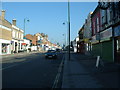
Shirley High Street, Southampton
Looking South from opposite Shirley Precinct.
Image: © GaryReggae
Taken: 12 Jul 2005
0.22 miles
9
Shirley High Street, Southampton
Looking South along Shirley High Street from the Precint, the freshly painted Windsor Castle pub dominates the left of the shot.
Image: © GaryReggae
Taken: 12 Jul 2005
0.22 miles
10
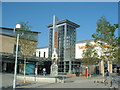
Sainsbury's, Shirley
The new Sainsbury's store in Shirley Precinct.
Image: © GaryReggae
Taken: 12 Jul 2005
0.22 miles