IMAGES TAKEN NEAR TO
Freshfield Square, SOUTHAMPTON, SO15 8QU
Introduction
This page details the photographs taken nearby to Freshfield Square, SO15 8QU by members of the Geograph project.
The Geograph project started in 2005 with the aim of publishing, organising and preserving representative images for every square kilometre of Great Britain, Ireland and the Isle of Man.

There are currently over 7.5m images from over14,400 individuals and you can help contribute to the project by visiting https://www.geograph.org.uk
Image Map
Images are licensed for reuse under creativecommons.org/licenses/by-sa/2.0
Notes
- Clicking on the map will re-center to the selected point.
- The higher the marker number, the further away the image location is from the centre of the postcode.
Image Listing (31 Images Found)
Images are licensed for reuse under creativecommons.org/licenses/by-sa/2.0
Image
Details
Distance
2
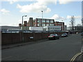
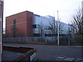
Shirley, tobacco factory
British American Tobacco, as seen from Waterhouse Lane; the main entrance is on Waterhouse Way. http://www.telegraph.co.uk/finance/2788851/Tobacco-and-health-The-smoking-gun.html
Image: © Mike Faherty
Taken: 2 Mar 2010
0.10 miles
3
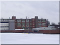
Old tobacco factory building in Millbrook
The imagine was taken from the top level of the nearby multi-storey car park. On the right the original factory building opened in 1926 can be seen with part of the newer factory on the left, opened in 1993. The factories were closed in 2006 when cigarette production was transferred abroad. Both buildings are now scheduled for demolition in the near future. During the 2nd World War the old factory was used for the production of the Spitfire fuel tank.
Image: © peter clayton
Taken: 6 Jan 2010
0.10 miles
4

Speckled bush cricket on a fig leaf
This Speckled bush cricket (Leptophyes punctatissima) is sitting on a fig leaf in an urban back yard. They are flightless, although they do have tiny brown flaps on top of the male's body. It is a plant feeder, although apparently not a pest in gardens.
Image: © Jim Champion
Taken: 23 Jul 2006
0.10 miles
5
British American Tobacco Research and Development Centre in Millbrook
from the junction of Waterhouse Lane and English Road
Image: © peter clayton
Taken: 29 Dec 2008
0.14 miles
6
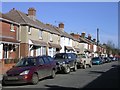
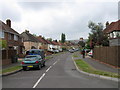
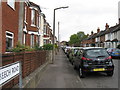
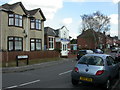
York Road, Shirley
A residential road typical of those between Shirley Road and Regents Park: semis and terraces, all built well before almost every household had a car. A few more modern houses have been squeezed into the gaps.
Image: © Jim Champion
Taken: 25 Feb 2006
0.14 miles
8
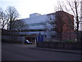
Entrance to British American Tobacco Research and Development Centre on Waterhouse Way
The R&D Centre is situated at the northern end of the BAT site in Millbrook which includes the former cigarette factory; cigarette production there ceased in 2006.
Image: © peter clayton
Taken: 29 Dec 2008
0.16 miles
9
Freemantle Baptist Church
In Testwood Road, off Waterhouse Lane. Foundation stones are dated 1911.
Image: © Mike Faherty
Taken: 2 Mar 2010
0.16 miles