IMAGES TAKEN NEAR TO
English Road, SOUTHAMPTON, SO15 8PR
Introduction
This page details the photographs taken nearby to English Road, SO15 8PR by members of the Geograph project.
The Geograph project started in 2005 with the aim of publishing, organising and preserving representative images for every square kilometre of Great Britain, Ireland and the Isle of Man.

There are currently over 7.5m images from over14,400 individuals and you can help contribute to the project by visiting https://www.geograph.org.uk
Image Map
Images are licensed for reuse under creativecommons.org/licenses/by-sa/2.0
Notes
- Clicking on the map will re-center to the selected point.
- The higher the marker number, the further away the image location is from the centre of the postcode.
Image Listing (77 Images Found)
Images are licensed for reuse under creativecommons.org/licenses/by-sa/2.0
Image
Details
Distance
1
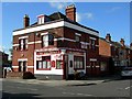
The Englishman
Pub in Freemantle on the corner of English Road and Imperial Avenue.
Image: © dennis huteson
Taken: 7 Oct 2006
0.03 miles
2
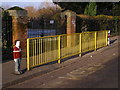
Railings outside Foundry Lane Primary School
This is the Foundry Lane gate to Foundry Lane Primary School, on the first day of the Christmas holiday 2007. The two plastic children have stood here, sentinel-like, since the summer.
Image: © Jim Champion
Taken: 20 Dec 2007
0.06 miles
3

Speckled bush cricket on a fig leaf
This Speckled bush cricket (Leptophyes punctatissima) is sitting on a fig leaf in an urban back yard. They are flightless, although they do have tiny brown flaps on top of the male's body. It is a plant feeder, although apparently not a pest in gardens.
Image: © Jim Champion
Taken: 23 Jul 2006
0.10 miles
4
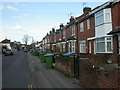
Shirley, Waterhouse Lane
This road runs from Millbrook Road to Shirley, and is mainly residential; mainly Victorian, with some pre-war development. Seen here, Victorian terraces.
Image: © Mike Faherty
Taken: 2 Mar 2010
0.11 miles
5
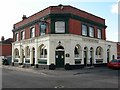
The Bald Faced Stag
Tucked away boozer on the corner of Edward Road and Kentish Road. If you didn't know this pub was there you'd never find it.
First time I've seen this as a pub name.
Image: © dennis huteson
Taken: 7 Oct 2006
0.13 miles
6
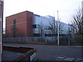
British American Tobacco Research and Development Centre in Millbrook
from the junction of Waterhouse Lane and English Road
Image: © peter clayton
Taken: 29 Dec 2008
0.13 miles
7
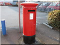
ER2 Post box
Post box at the entrance to Royal Mail Depot in Villiers Road.
Image: © Alex McGregor
Taken: 7 Mar 2010
0.13 miles
8
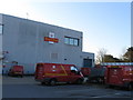
Royal Mail Depot
Royal mail depot, part of the former MFI building.
Image: © Alex McGregor
Taken: 7 Mar 2010
0.15 miles
9
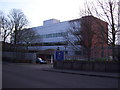
Entrance to British American Tobacco Research and Development Centre on Waterhouse Way
The R&D Centre is situated at the northern end of the BAT site in Millbrook which includes the former cigarette factory; cigarette production there ceased in 2006.
Image: © peter clayton
Taken: 29 Dec 2008
0.16 miles
10
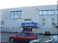
Fitness First
A gym in part of the former MFI building.
Image: © Alex McGregor
Taken: 7 Mar 2010
0.16 miles