IMAGES TAKEN NEAR TO
King Georges Avenue, SOUTHAMPTON, SO15 4JE
Introduction
This page details the photographs taken nearby to King Georges Avenue, SO15 4JE by members of the Geograph project.
The Geograph project started in 2005 with the aim of publishing, organising and preserving representative images for every square kilometre of Great Britain, Ireland and the Isle of Man.

There are currently over 7.5m images from over14,400 individuals and you can help contribute to the project by visiting https://www.geograph.org.uk
Image Map
Images are licensed for reuse under creativecommons.org/licenses/by-sa/2.0
Notes
- Clicking on the map will re-center to the selected point.
- The higher the marker number, the further away the image location is from the centre of the postcode.
Image Listing (40 Images Found)
Images are licensed for reuse under creativecommons.org/licenses/by-sa/2.0
Image
Details
Distance
1
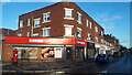
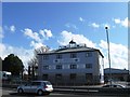
Greggs Outlet shop, Millbrook Road West
According to their website, a shop where unsold food is redistributed and sold at a lower price "to tackle food waste, while allowing people in disadvantaged areas to enjoy our food at a huge discount". The main A35 dual carriageway runs to the right of this image.
Image: © David Martin
Taken: 14 Nov 2023
0.02 miles
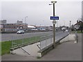
3
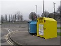
Recycling facilities, Millbrook
Recycling facilities at the junction of King George's Avenue and Millbrook Road. On the far side of the A3024 dual carriageway is the recreation ground and the railway line. The two CCTV cameras are watching the access ramps/stairs to the subway that passes beneath the dual carriageway.
Image: © Jim Champion
Taken: 18 Feb 2007
0.04 miles
4
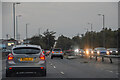
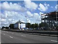
Southampton : Millbrook Road West A33
Heading along Millbrook Road West.
Image: © Lewis Clarke
Taken: 18 Oct 2020
0.05 miles
5
Subway ramp north of the A3024 dual carriageway, Millbrook
This is the northern side of the subway beneath the A3024 dual carriageway (Millbrook Road West). This side of the road is mainly residential, the far side is more business and industry. People do still try and cross the main road without using the subway but it's not a very sensible idea.
Image: © Jim Champion
Taken: 18 Feb 2007
0.05 miles
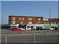
8
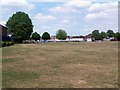
Millbrook Recreation Ground
View from the south west corner looking back towards Millbrook Road
Image: © David Martin
Taken: 27 Jun 2010
0.09 miles