IMAGES TAKEN NEAR TO
Manningford Bohune, PEWSEY, SN9 6NL
Introduction
This page details the photographs taken nearby to SN9 6NL by members of the Geograph project.
The Geograph project started in 2005 with the aim of publishing, organising and preserving representative images for every square kilometre of Great Britain, Ireland and the Isle of Man.

There are currently over 7.5m images from over14,400 individuals and you can help contribute to the project by visiting https://www.geograph.org.uk
Image Map (Loading...)


Getting Data...Please wait
Leaflet Map data © OpenStreetMap
Images are licensed for reuse under creativecommons.org/licenses/by-sa/2.0
Notes
- Clicking on the map will re-center to the selected point.
- The higher the marker number, the further away the image location is from the centre of the postcode.
Image Listing (16 Images Found)
Images are licensed for reuse under creativecommons.org/licenses/by-sa/2.0
Image
Details
Distance
2
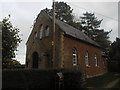
Providence Strict and Particular Baptist Chapel
Image: © Basher Eyre
Taken: 27 Oct 2014
0.16 miles
4
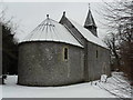
St. Peter's church
A rare early Norman church, carefully restored in 1882 by J.L. Pearson
Image: © Kevin Farmer
Taken: 10 Jan 2010
0.22 miles
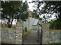
5
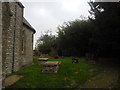
St. Peter, Mannington Bruce: tombs in the churchyard
Image: © Basher Eyre
Taken: 27 Oct 2014
0.23 miles
6
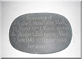
St. Peter's Church, Mannington Bruce: memorial
Image: © Basher Eyre
Taken: 27 Oct 2014
0.23 miles
7
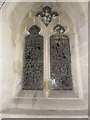
Inside St. Peter's Church, Mannington Bruce (d)
Image: © Basher Eyre
Taken: 27 Oct 2014
0.23 miles
8
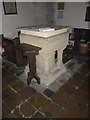
St. Peter's Church, Mannington Bruce: font
Image: © Basher Eyre
Taken: 27 Oct 2014
0.23 miles
9
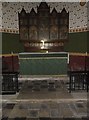
St. Peter's Church, Mannington Bruce: altar
Image: © Basher Eyre
Taken: 27 Oct 2014
0.23 miles
10

Inside St. Peter's Church, Mannington Bruce (a)
Image: © Basher Eyre
Taken: 27 Oct 2014
0.23 miles