IMAGES TAKEN NEAR TO
Manningford Bruce, PEWSEY, SN9 6JF
Introduction
This page details the photographs taken nearby to SN9 6JF by members of the Geograph project.
The Geograph project started in 2005 with the aim of publishing, organising and preserving representative images for every square kilometre of Great Britain, Ireland and the Isle of Man.

There are currently over 7.5m images from over14,400 individuals and you can help contribute to the project by visiting https://www.geograph.org.uk
Image Map
Images are licensed for reuse under creativecommons.org/licenses/by-sa/2.0
Notes
- Clicking on the map will re-center to the selected point.
- The higher the marker number, the further away the image location is from the centre of the postcode.
Image Listing (10 Images Found)
Images are licensed for reuse under creativecommons.org/licenses/by-sa/2.0
Image
Details
Distance
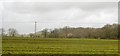
1
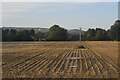
Field off Dragon Lane
Field and trees near Pewsey.
Image: © Wayland Smith
Taken: 30 Mar 2021
0.06 miles
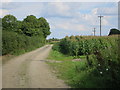
2
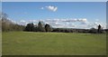
Primrose Lane
Alpacas graze by the railway line west of Pewsey. In front of the houses runs BOAT MANN 36.
Image: © Derek Harper
Taken: 30 Sep 2015
0.11 miles
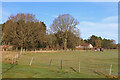
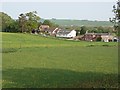
4
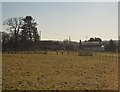
Pasture, Manningford Bruce
With scattered buildings to the north of the village. Taken from a train on the main line just west of the site of Manningford Halt.
Image: © Derek Harper
Taken: 19 Mar 2012
0.14 miles
7
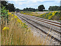
The railway, Manningford Bruce
Viewed from one of the area's several pedestrian level crossings. Ragwort makes a colourful addition to the trackside.
Image: © Andrew Smith
Taken: 25 Jul 2009
0.19 miles
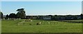
8
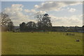
Manningford Bruce
Houses on Primrose Lane viewed across paddocks with plentiful dandelions.
Image: © Andrew Smith
Taken: 28 Apr 2007
0.19 miles