IMAGES TAKEN NEAR TO
Beechingstoke, PEWSEY, SN9 6HJ
Introduction
This page details the photographs taken nearby to SN9 6HJ by members of the Geograph project.
The Geograph project started in 2005 with the aim of publishing, organising and preserving representative images for every square kilometre of Great Britain, Ireland and the Isle of Man.

There are currently over 7.5m images from over14,400 individuals and you can help contribute to the project by visiting https://www.geograph.org.uk
Image Map (Loading...)


Getting Data...Please wait
Leaflet Map data © OpenStreetMap
Images are licensed for reuse under creativecommons.org/licenses/by-sa/2.0
Notes
- Clicking on the map will re-center to the selected point.
- The higher the marker number, the further away the image location is from the centre of the postcode.
Image Listing (32 Images Found)
Images are licensed for reuse under creativecommons.org/licenses/by-sa/2.0
Image
Details
Distance

10
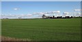
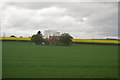
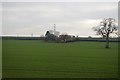
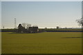
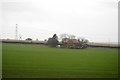
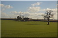
Field and houses near Piccadilly
Piccadilly, Wiltshire, that is. The three pairs of semis on Woodnorough Road form a touch of ribbon development in the open countryside. An isolated oak stands near them at the side of this large field of ... grass? View from a train on the main line between Pewsey and Westbury.
Image: © Derek Harper
Taken: 19 Mar 2012
0.09 miles