IMAGES TAKEN NEAR TO
Pewsey Road, PEWSEY, SN9 6EN
Introduction
This page details the photographs taken nearby to Pewsey Road, SN9 6EN by members of the Geograph project.
The Geograph project started in 2005 with the aim of publishing, organising and preserving representative images for every square kilometre of Great Britain, Ireland and the Isle of Man.

There are currently over 7.5m images from over14,400 individuals and you can help contribute to the project by visiting https://www.geograph.org.uk
Image Map (Loading...)


Getting Data...Please wait
Leaflet Map data © OpenStreetMap
Images are licensed for reuse under creativecommons.org/licenses/by-sa/2.0
Notes
- Clicking on the map will re-center to the selected point.
- The higher the marker number, the further away the image location is from the centre of the postcode.
Image Listing (25 Images Found)
Images are licensed for reuse under creativecommons.org/licenses/by-sa/2.0
Image
Details
Distance
1
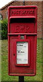
Elizabeth II postbox on Pewsey Road, Rushall
Postbox No. SN9 82.
See Image] for context.
Image: © JThomas
Taken: 13 Jul 2019
0.02 miles
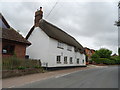
2
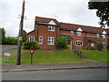
Houses on Pewsey Road, Rushall
Showing position of Postbox No. SN9 82.
See Image] for postbox.
Image: © JThomas
Taken: 13 Jul 2019
0.03 miles
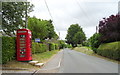
4
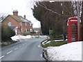
Telephone box, Rushall
A K6 type telephone box beside the main road through the village.
Image: © Maigheach-gheal
Taken: 14 Jan 2010
0.09 miles
6
K6 telephone box on Pewsey Road, Rushall
Now in use as a book exchange.
Image: © JThomas
Taken: 13 Jul 2019
0.09 miles
7
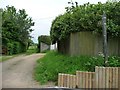
Public footpath, east side of Pewsey Road, Rushall
Leading south to the parish church.
Image: © Christine Johnstone
Taken: 26 May 2014
0.14 miles
8
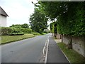
Pewsey Road, Rushall
A short cut between the A342 and the A345. Looking north.
Image: © Christine Johnstone
Taken: 26 May 2014
0.15 miles
9
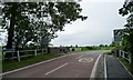
Rushall Bridge from the south-west
Carrying Pewsey Road over the River Avon, at the northern edge of the village. The bridge was widened in 1936.
Image: © Christine Johnstone
Taken: 26 May 2014
0.16 miles
10
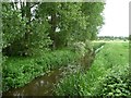
River Avon, Rushall
Upstream [west] of Rushall Bridge.
Image: © Christine Johnstone
Taken: 26 May 2014
0.17 miles