IMAGES TAKEN NEAR TO
Paddock Close, PEWSEY, SN9 6DN
Introduction
This page details the photographs taken nearby to Paddock Close, SN9 6DN by members of the Geograph project.
The Geograph project started in 2005 with the aim of publishing, organising and preserving representative images for every square kilometre of Great Britain, Ireland and the Isle of Man.

There are currently over 7.5m images from over14,400 individuals and you can help contribute to the project by visiting https://www.geograph.org.uk
Image Map (Loading...)


Getting Data...Please wait
Leaflet Map data © OpenStreetMap
Images are licensed for reuse under creativecommons.org/licenses/by-sa/2.0
Notes
- Clicking on the map will re-center to the selected point.
- The higher the marker number, the further away the image location is from the centre of the postcode.
Image Listing (3 Images Found)
Images are licensed for reuse under creativecommons.org/licenses/by-sa/2.0
Image
Details
Distance
1
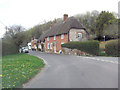
Old Bengers
This cottage is Grade II listed and dates from the early 19th C. It uses locally available vernacular building materials: thatch, flint, brick and clunch. The latter is a soft rock comprising naturally compressed chalk. It does not weather well but is readily available in calciferous areas. English Heritage Building ID: 310987.
Image: © Stuart Logan
Taken: 25 Apr 2013
0.14 miles
2
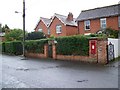
Postbox, Enford
The postbox is George VI.
Image: © Maigheach-gheal
Taken: 6 Sep 2008
0.20 miles
3
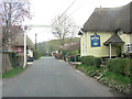
Un-named road passes The Swan Public House
This Grade II listed pub was originally an ale-house in the 17th C. Extended during the 18th C it now has English Heritage Building ID: 310995 and an interesting device to stop lost HGV's from driving past. See also: http://www.britishlistedbuildings.co.uk/en-310995-the-swan-public-house-enford-
Image: © Stuart Logan
Taken: 25 Apr 2013
0.22 miles