IMAGES TAKEN NEAR TO
Grants Road, PEWSEY, SN9 6DB
Introduction
This page details the photographs taken nearby to Grants Road, SN9 6DB by members of the Geograph project.
The Geograph project started in 2005 with the aim of publishing, organising and preserving representative images for every square kilometre of Great Britain, Ireland and the Isle of Man.

There are currently over 7.5m images from over14,400 individuals and you can help contribute to the project by visiting https://www.geograph.org.uk
Image Map (Loading...)


Getting Data...Please wait
Leaflet Map data © OpenStreetMap
Images are licensed for reuse under creativecommons.org/licenses/by-sa/2.0
Notes
- Clicking on the map will re-center to the selected point.
- The higher the marker number, the further away the image location is from the centre of the postcode.
Image Listing (22 Images Found)
Images are licensed for reuse under creativecommons.org/licenses/by-sa/2.0
Image
Details
Distance
1
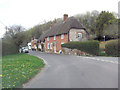
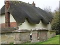
Old Bengers
This cottage is Grade II listed and dates from the early 19th C. It uses locally available vernacular building materials: thatch, flint, brick and clunch. The latter is a soft rock comprising naturally compressed chalk. It does not weather well but is readily available in calciferous areas. English Heritage Building ID: 310987.
Image: © Stuart Logan
Taken: 25 Apr 2013
0.08 miles
2
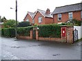
Postbox, Enford
The postbox is George VI.
Image: © Maigheach-gheal
Taken: 6 Sep 2008
0.16 miles
3
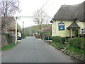
Un-named road passes The Swan Public House
This Grade II listed pub was originally an ale-house in the 17th C. Extended during the 18th C it now has English Heritage Building ID: 310995 and an interesting device to stop lost HGV's from driving past. See also: http://www.britishlistedbuildings.co.uk/en-310995-the-swan-public-house-enford-
Image: © Stuart Logan
Taken: 25 Apr 2013
0.18 miles
4
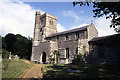
All Saints Church, Enford
The oldest surviving portions of the present building are the walls and pillars of the nave, and the remnants of an early church arch. The chancel arch is late Norman, as is the doorway to the south porch. In the 13th century the style of architecture changed rapidly, as the heavy Norman design gave way to lighter, more graceful lines.
During the Middle Ages and for some time afterwards the church was almost bare, with the altar table being the only piece of furniture. The floor would have been strewn with rushes, and often scented herbs, which were replaced twice yearly.
The church also housed the local school from as early as 1552 to the late 19th century, latterly in the north aisle.
Image: © Maigheach-gheal
Taken: 26 Feb 2009
0.19 miles
5
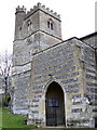
Porch, All Saints Church, Enford
The porch leads to a late Norman doorway, both of these were restored, using the original stones from the fallen spire.
Image: © Maigheach-gheal
Taken: 26 Feb 2009
0.20 miles
6
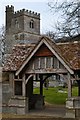
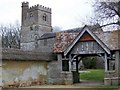
Lychgate and All Saints Church, Enford
Image: © David Martin
Taken: 12 Feb 2015
0.20 miles
7
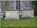
Tombs, All Saints Church, Enford
A pair of Grade II listed late 18th century chest tombs made of limestone.
Image: © Maigheach-gheal
Taken: 26 Feb 2009
0.20 miles
9
Tombs, All Saints Church, Enford
Three grade II listed chest tombs for members of the Baden family.
Image: © Maigheach-gheal
Taken: 26 Feb 2009
0.20 miles
10
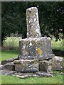
Stone Cross, All Saints Church, Enford
On the right of the path, as you approach the church, is the stump of an ancient stone cross. This is either a village or churchyard cross and was known to be in its present position in 1007.
Image: © Maigheach-gheal
Taken: 26 Feb 2009
0.20 miles