IMAGES TAKEN NEAR TO
Compton, PEWSEY, SN9 6AZ
Introduction
This page details the photographs taken nearby to Compton, SN9 6AZ by members of the Geograph project.
The Geograph project started in 2005 with the aim of publishing, organising and preserving representative images for every square kilometre of Great Britain, Ireland and the Isle of Man.

There are currently over 7.5m images from over14,400 individuals and you can help contribute to the project by visiting https://www.geograph.org.uk
Image Map (Loading...)


Getting Data...Please wait
Leaflet Map data © OpenStreetMap
Images are licensed for reuse under creativecommons.org/licenses/by-sa/2.0
Notes
- Clicking on the map will re-center to the selected point.
- The higher the marker number, the further away the image location is from the centre of the postcode.
Image Listing (7 Images Found)
Images are licensed for reuse under creativecommons.org/licenses/by-sa/2.0
Image
Details
Distance
1
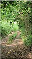
Compton Farm, Wiltshire
A shady bridleway heading north in the vicinity of Compton Farm.
Image: © Rebecca A Wills
Taken: 18 Sep 2021
0.07 miles
2

Compton Farm, Wiltshire
Fully defended pasture land at Compton Farm!
Image: © Rebecca A Wills
Taken: 18 Sep 2021
0.08 miles
3
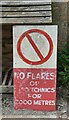
Compton Farm, Wiltshire
An old military danger sign in the grounds of Compton Farm.
Image: © Rebecca A Wills
Taken: 18 Sep 2021
0.09 miles
4
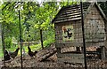
Compton Farm, Wiltshire
A lovey sign reading 'Fresh Eggs' on the side of a chicken coup at Compton Farm.
Image: © Rebecca A Wills
Taken: 18 Sep 2021
0.09 miles
5

Compton Farm, Wiltshire
A cheery Zebedee sculpture standing on a gate post at Compton Farm.
Image: © Rebecca A Wills
Taken: 18 Sep 2021
0.10 miles
6
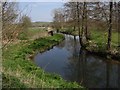
River Avon, Compton
Well below the A345 which is up a steep bank.
Image: © Andrew Smith
Taken: 8 Apr 2007
0.17 miles
7
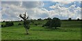
Water Dean Bottom, Wiltshire
Pasture land on Water Dean Bottom in the vicinity of Compton Farm.
Image: © Rebecca A Wills
Taken: 18 Sep 2021
0.21 miles