IMAGES TAKEN NEAR TO
Enford Farm Road, PEWSEY, SN9 6AT
Introduction
This page details the photographs taken nearby to Enford Farm Road, SN9 6AT by members of the Geograph project.
The Geograph project started in 2005 with the aim of publishing, organising and preserving representative images for every square kilometre of Great Britain, Ireland and the Isle of Man.

There are currently over 7.5m images from over14,400 individuals and you can help contribute to the project by visiting https://www.geograph.org.uk
Image Map (Loading...)


Getting Data...Please wait
Leaflet Map data © OpenStreetMap
Images are licensed for reuse under creativecommons.org/licenses/by-sa/2.0
Notes
- Clicking on the map will re-center to the selected point.
- The higher the marker number, the further away the image location is from the centre of the postcode.
Image Listing (20 Images Found)
Images are licensed for reuse under creativecommons.org/licenses/by-sa/2.0
Image
Details
Distance
1
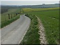
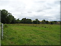
Lane and farmland, Enford
Zigzagging stretch of the lane leading to Enford Farm.
Image: © Andrew Smith
Taken: 8 Apr 2007
0.08 miles
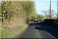
3
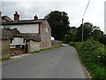
Cottages in Enford Hill, Enford
Enford is a small Wiltshire village bisected by the A345 highway which runs north to south through the county. Enford Hill is west of the A345 and provides access to Enford Farm, about 1.5 kilometres away. The thatched cottages are typical of many to be found in these parts.
Image: © Brian Robert Marshall
Taken: 12 Apr 2011
0.13 miles
4
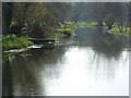
River Avon, Enford
Looking downstream from the road bridge.
Image: © Andrew Smith
Taken: 8 Apr 2007
0.18 miles
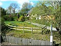
5

Track, Enford
The track which acts as a bridleway takes riders back to the A345.
Image: © Maigheach-gheal
Taken: 6 Jun 2010
0.19 miles
6
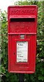
Elizabeth II postbox on Enford Hill, Enford
Postbox No. SN9 163.
Image: © JThomas
Taken: 13 Jul 2019
0.19 miles
7
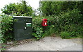
Elizabeth II postbox and Openreach fibre cabinet on Enford Hill, Enford
Postbox No. SN9 163.
Image: © JThomas
Taken: 13 Jul 2019
0.20 miles
9
Endford Hill
Crosses the River Avon towards Longstreet.
Image: © JThomas
Taken: 13 Jul 2019
0.21 miles
10
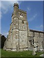
All Saints', Enford
It previously had a spire that was visible for 20 miles but it was struck by lightning in 1817. The church was restored without the spire in 1831 at a cost of £2300.
Image: © Andrew Smith
Taken: 8 Apr 2007
0.21 miles