IMAGES TAKEN NEAR TO
North Street, PEWSEY, SN9 5NX
Introduction
This page details the photographs taken nearby to North Street, SN9 5NX by members of the Geograph project.
The Geograph project started in 2005 with the aim of publishing, organising and preserving representative images for every square kilometre of Great Britain, Ireland and the Isle of Man.

There are currently over 7.5m images from over14,400 individuals and you can help contribute to the project by visiting https://www.geograph.org.uk
Image Map
Images are licensed for reuse under creativecommons.org/licenses/by-sa/2.0
Notes
- Clicking on the map will re-center to the selected point.
- The higher the marker number, the further away the image location is from the centre of the postcode.
Image Listing (218 Images Found)
Images are licensed for reuse under creativecommons.org/licenses/by-sa/2.0
Image
Details
Distance
1
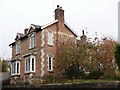
79 North Street
Nicely mannered brick house.
Image: © Michael Dibb
Taken: 15 Nov 2016
0.00 miles
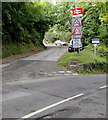
2
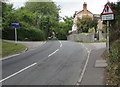
Warning sign - no footway for 120 yards, Marlborough Road, Pewsey
Alongside the A345 Marlborough Road on the corner of Buckleaze Lane.
Image: © Jaggery
Taken: 15 Sep 2018
0.02 miles
3
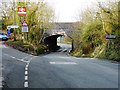
Pewsey - Railway Bridge
Nice camber on this road makes for a little excitement in bad weather.
Image: © Chris Talbot
Taken: 19 Feb 2012
0.03 miles
4
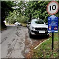
Welcome to Pewsey station car park
Maximum speed 10 mph in the pay & display car park.
Image: © Jaggery
Taken: 15 Sep 2018
0.04 miles
5
Pewsey railway station access road
From the A345 Marlborough Road. The arch bridge warning signs are for this https://www.geograph.org.uk/photo/5968131 bridge over the A345.
Image: © Jaggery
Taken: 15 Sep 2018
0.04 miles
6
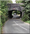
South side of a low railway bridge, Pewsey
Over the A345 Marlborough Road near Pewsey railway station.
Headroom shown is 4.5m (14' 9") - this clearance applies only
under the centre of arch bridge, between the two vertical markers.
Image: © Jaggery
Taken: 15 Sep 2018
0.04 miles
7
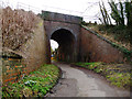
Pewsey - Railway Bridge
This footpath leads under the main railway line.
Image: © Chris Talbot
Taken: 19 Feb 2012
0.04 miles
8
Buckleaze Lane
The 'no through road' lane passes under the railway.
Image: © Michael Dibb
Taken: 15 Nov 2016
0.04 miles
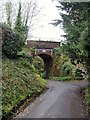
9
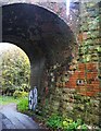
Extended bridge
The width of the bridge was changed when the line was doubled.
Image: © Michael Dibb
Taken: 15 Nov 2016
0.04 miles
10
Arch bridge
The railway line runs from Reading to Taunton, a major branch of the Great Western Main Line.
Image: © Michael Dibb
Taken: 15 Nov 2016
0.04 miles