IMAGES TAKEN NEAR TO
Dursden Lane, PEWSEY, SN9 5JN
Introduction
This page details the photographs taken nearby to Dursden Lane, SN9 5JN by members of the Geograph project.
The Geograph project started in 2005 with the aim of publishing, organising and preserving representative images for every square kilometre of Great Britain, Ireland and the Isle of Man.

There are currently over 7.5m images from over14,400 individuals and you can help contribute to the project by visiting https://www.geograph.org.uk
Image Map (Loading...)


Getting Data...Please wait
Leaflet Map data © OpenStreetMap
Images are licensed for reuse under creativecommons.org/licenses/by-sa/2.0
Notes
- Clicking on the map will re-center to the selected point.
- The higher the marker number, the further away the image location is from the centre of the postcode.
Image Listing (8 Images Found)
Images are licensed for reuse under creativecommons.org/licenses/by-sa/2.0
Image
Details
Distance
1
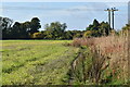
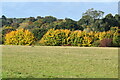
Path beside the railway, north of Pewsey
The Dursden Lane end of the footpath marked on the OS map is thoroughly blocked by brambles and impassable, but a clear path crosses the field next to the railway cutting.
Image: © David Martin
Taken: 17 Oct 2022
0.09 miles
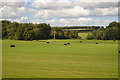
5
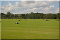
View into Jones's Mill Nature Reserve from Dursden Lane
Image: © David Martin
Taken: 17 Oct 2022
0.19 miles
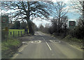
7
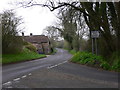
Minor road arrives at the B3087 near Pewsey (2)
The view is along the B road towards Pewsey.
Image: © Shazz
Taken: 27 Apr 2013
0.20 miles
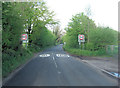
8
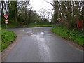
Minor road arrives at the B3087 near Pewsey (1)
There is a bridleway opposite.
Image: © Shazz
Taken: 27 Apr 2013
0.25 miles