IMAGES TAKEN NEAR TO
Nether Leaze, PEWSEY, SN9 5HQ
Introduction
This page details the photographs taken nearby to Nether Leaze, SN9 5HQ by members of the Geograph project.
The Geograph project started in 2005 with the aim of publishing, organising and preserving representative images for every square kilometre of Great Britain, Ireland and the Isle of Man.

There are currently over 7.5m images from over14,400 individuals and you can help contribute to the project by visiting https://www.geograph.org.uk
Image Map (44 Images)


Getting Data...Please wait
Leaflet Map data © OpenStreetMap
Images are licensed for reuse under creativecommons.org/licenses/by-sa/2.0
Notes
- Clicking on the map will re-center to the selected point.
- The higher the marker number, the further away the image location is from the centre of the postcode.
Image Listing (44 Images Found)
Images are licensed for reuse under creativecommons.org/licenses/by-sa/2.0
Image
Details
Distance
1
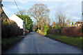
Wilcot Road, Pewsey
Heading out of town towards Wilcot.
Image: © Robin Webster
Taken: 9 Jan 2022
0.06 miles
2
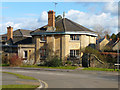
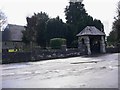
Pewsey - Former Workhouse Lodge
This former lodge house has been converted into a house.
Image: © Chris Talbot
Taken: 19 Feb 2012
0.07 miles
4
Pewsey - Former Union Workhouse
Pewsey Union workhouse was erected in 1836 on a site at the west of Pewsey. The Poor Law Commissioners authorised an expenditure of £3,213 on construction of the building which was to accommodate 200 inmates. It has nowbeen converted into housing.
Image: © Chris Talbot
Taken: 19 Feb 2012
0.07 miles
5
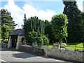
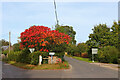
Entrance to the Cemetery in Pewsey
Image: © Richard Humphrey
Taken: 10 Jul 2016
0.08 miles
6
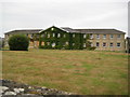
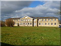
Pewsey: Former Union Workhouse
Pewsey Union Workhouse was built here on Walcot Road in 1836. By 1926 the Ordnance Survey were describing the building as the Poor Law Institution, and by 1930 it had become Pewsey Mental Hospital. The building has now been redeveloped as private housing and the site is surrounded on three sides by new homes. However the windows of the building on the ground floor on the left are currently boarded up.
Image: © Nigel Cox
Taken: 10 Jul 2009
0.08 miles
8
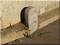
Pewsey - Boundary Marker
An old War Department boundary marker in Woodborough Road.
Image: © Chris Talbot
Taken: 19 Feb 2012
0.08 miles
9
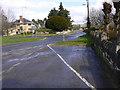
Looking east along Wilcot Road from the junction with Woodborough Road
The cemetery wall is on the right.
Image: © Shazz
Taken: 27 Apr 2013
0.09 miles
10
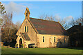
Former Chapel
Former Chapel in Pewsey.
Image: © Wayland Smith
Taken: 24 Dec 2020
0.09 miles