IMAGES TAKEN NEAR TO
Avonleaze Road, PEWSEY, SN9 5AX
Introduction
This page details the photographs taken nearby to Avonleaze Road, SN9 5AX by members of the Geograph project.
The Geograph project started in 2005 with the aim of publishing, organising and preserving representative images for every square kilometre of Great Britain, Ireland and the Isle of Man.

There are currently over 7.5m images from over14,400 individuals and you can help contribute to the project by visiting https://www.geograph.org.uk
Image Map (Loading...)


Getting Data...Please wait
Leaflet Map data © OpenStreetMap
Images are licensed for reuse under creativecommons.org/licenses/by-sa/2.0
Notes
- Clicking on the map will re-center to the selected point.
- The higher the marker number, the further away the image location is from the centre of the postcode.
Image Listing (244 Images Found)
Images are licensed for reuse under creativecommons.org/licenses/by-sa/2.0
Image
Details
Distance
1
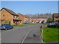
Bramley Close, Pewsey
Modern houses on the northern edge of the town.
Image: © Andrew Smith
Taken: 24 Mar 2012
0.12 miles
2
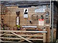
An interesting collection
Some interesting sign at 61 High Street.
Image: © Michael Dibb
Taken: 15 Nov 2016
0.14 miles
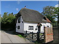
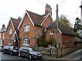
4
2 Brunkards Lane
The small oriel window and the eyebrow window make this delightful cottage.
Image: © Michael Dibb
Taken: 15 Nov 2016
0.14 miles
5
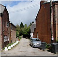
Brunkards Lane, Pewsey
Dead-end lane on the north side of High Street.
Image: © Jaggery
Taken: 15 Sep 2018
0.14 miles
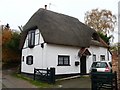
6
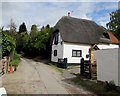
Thatched cottage, Brunkards Lane, Pewsey
In the background on the right here. https://www.geograph.org.uk/photo/5969572
Image: © Jaggery
Taken: 15 Sep 2018
0.14 miles
7
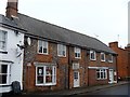
59 & 61 High Street
The variations in the brickwork suggests that these two houses have been much altered and are now business premises.
Image: © Michael Dibb
Taken: 15 Nov 2016
0.14 miles
8
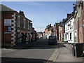
Pewsey, High Street
Looking towards Market Place.
Image: © Mike Faherty
Taken: 16 Mar 2010
0.15 miles
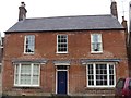
9
49 High Street
Known as The Chantry, this delightful house is circa 1870. Listed, grade II, with details at: https://www.historicengland.org.uk/listing/the-list/list-entry/1035708
Image: © Michael Dibb
Taken: 15 Nov 2016
0.15 miles
10
47 High Street
This late 18th century house is known as Mayfield. Listed, grade II, with details at: https://www.historicengland.org.uk/listing/the-list/list-entry/1035707
Image: © Michael Dibb
Taken: 15 Nov 2016
0.15 miles