IMAGES TAKEN NEAR TO
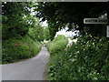
Wootton Rivers, MARLBOROUGH, SN8 4NS
Introduction
This page details the photographs taken nearby to SN8 4NS by members of the Geograph project.
The Geograph project started in 2005 with the aim of publishing, organising and preserving representative images for every square kilometre of Great Britain, Ireland and the Isle of Man.

There are currently over 7.5m images from over14,400 individuals and you can help contribute to the project by visiting https://www.geograph.org.uk
Image Map
Images are licensed for reuse under creativecommons.org/licenses/by-sa/2.0
Notes
- Clicking on the map will re-center to the selected point.
- The higher the marker number, the further away the image location is from the centre of the postcode.
Image Listing (11 Images Found)
Images are licensed for reuse under creativecommons.org/licenses/by-sa/2.0
Image
Details
Distance
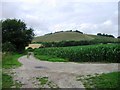
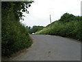
1
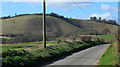
2012 : Minor road out of Wootton Rivers
To the north west.
Farmland, post and Martinsell Hill. A fine viewpoint there but no footpath.
Image: © Maurice Pullin
Taken: 5 Mar 2012
0.11 miles
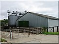
8
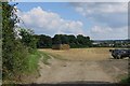
2012 : Field of oilseed rape near Wotton Rivers
From the minor road to East Wick Farm.
The farm buildings and house are at Clench.
Image: © Maurice Pullin
Taken: 5 Mar 2012
0.19 miles
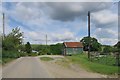
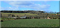
10
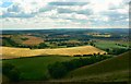
Farmland east of Martinsell Hill, near Wootton Rivers
The farm discernible in the centre of the image is East Wick Farm, about a kilometre east of the viewpoint. It lies in the Wootton Rivers Civil Parish. In the foreground is the eastern shoulder of Martinsell Hill.
Image: © Brian Robert Marshall
Taken: 24 Jul 2011
0.24 miles