IMAGES TAKEN NEAR TO
Brimslade, MARLBOROUGH, SN8 4NG
Introduction
This page details the photographs taken nearby to SN8 4NG by members of the Geograph project.
The Geograph project started in 2005 with the aim of publishing, organising and preserving representative images for every square kilometre of Great Britain, Ireland and the Isle of Man.

There are currently over 7.5m images from over14,400 individuals and you can help contribute to the project by visiting https://www.geograph.org.uk
Image Map (Loading...)


Getting Data...Please wait
Leaflet Map data © OpenStreetMap
Images are licensed for reuse under creativecommons.org/licenses/by-sa/2.0
Notes
- Clicking on the map will re-center to the selected point.
- The higher the marker number, the further away the image location is from the centre of the postcode.
Image Listing (47 Images Found)
Images are licensed for reuse under creativecommons.org/licenses/by-sa/2.0
Image
Details
Distance
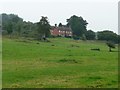
1

Buildings at Brimslade Farm
On the north bank of the Kennet & Avon Canal. Now mapped as The Old Granary.
Image: © Christine Johnstone
Taken: 7 May 2015
0.07 miles
2
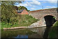
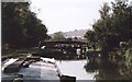
Bridge below Brimslade Lock
The farm buildings on the far side of the canal include a craft centre.
Image: © David Martin
Taken: 16 Oct 2022
0.09 miles
3
East of Brimslade Lock, Kennet and Avon Canal, Brimslade, Wiltshire
The view east shows the next bridge to the east, Bridge 105. The gates to Cadley Lock are visible under the arch. As is occasionally the case lock and bridge names can be confused and confusing. Cadley Lock is clearly named as such both on the ground and the Ordnance Survey map. Yet Wikipedia claims it is now called Wootton Top Lock. This makes some sense as Cadley is 3 kilometres away to the north nowhere near the canal whilst Wootton Rivers Lock is only 1.4 kilometres west on the canal.
Image: © Brian Robert Marshall
Taken: 8 Sep 2014
0.09 miles
4
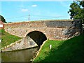
Bridge 106, Kennet and Avon Canal, Brimslade, Wiltshire
Bridge 106 is just west of Brimslade Lock the gates of which are barely visible under the arch. There is just a short stretch (240 metres) between Brimslade Lock and Cadley Lock to the east, also with its own bridge, Bridge 105. The locks and bridges are bundled together for listing purposes http://www.imagesofengland.org.uk/details/default.aspx?id=311757
Image: © Brian Robert Marshall
Taken: 8 Sep 2014
0.09 miles
5
![Brimslade Bridge [No 106] from the north](https://s3.geograph.org.uk/geophotos/04/49/48/4494887_ebc6af02_120x120.jpg)
Brimslade Bridge [No 106] from the north
The yellow sign warns that five small children may be crossing.
Image: © Christine Johnstone
Taken: 7 May 2015
0.10 miles
6
![Brimslade bridge [no 106] and lock [no 53]](https://s0.geograph.org.uk/geophotos/03/70/43/3704308_5529ec8f_120x120.jpg)
Brimslade bridge [no 106] and lock [no 53]
The lock is empty and open for the photographer's approaching east-bound narrowboat.
Image: © Christine Johnstone
Taken: 2 Oct 2013
0.10 miles
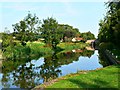
7
Paddocks east of Brimslade Farm
Sloping up from the north bank of the canal.
Image: © Christine Johnstone
Taken: 30 Sep 2013
0.10 miles
8
![Lock moorings below Brimslade Lock [no 53]](https://s0.geograph.org.uk/geophotos/03/70/06/3700676_38f602af_120x120.jpg)
Lock moorings below Brimslade Lock [no 53]
Seen from Brimslade Bridge [no 106].
Image: © Christine Johnstone
Taken: 30 Sep 2013
0.10 miles
9
Brimslade Lock and Bridge, Kennet and Avon Canal 2003
Brimslade Lock - No.53 - from the east with Brimslade Bridge - No.106 - behind.
Martinsell Hill is on the skyline.
Image: © Maurice Pullin
Taken: 25 Sep 2003
0.10 miles
10
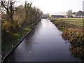
Kennet & Avon canal looking west to Brimslade Farm
Photo taken from bridge 200m east of lock, bridge and Brimslade Farm.
Image: © Roger Thomas
Taken: 20 Nov 2005
0.10 miles