IMAGES TAKEN NEAR TO
Church Walk, MARLBOROUGH, SN8 4LL
Introduction
This page details the photographs taken nearby to Church Walk, SN8 4LL by members of the Geograph project.
The Geograph project started in 2005 with the aim of publishing, organising and preserving representative images for every square kilometre of Great Britain, Ireland and the Isle of Man.

There are currently over 7.5m images from over14,400 individuals and you can help contribute to the project by visiting https://www.geograph.org.uk
Image Map
Images are licensed for reuse under creativecommons.org/licenses/by-sa/2.0
Notes
- Clicking on the map will re-center to the selected point.
- The higher the marker number, the further away the image location is from the centre of the postcode.
Image Listing (81 Images Found)
Images are licensed for reuse under creativecommons.org/licenses/by-sa/2.0
Image
Details
Distance
1
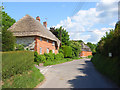
The Street, Stanton St Bernard
Corner Cottage at the junction of The Street (ahead), Church Road (behind) and Coate Lane (left).
Image: © Andrew Smith
Taken: 7 Jun 2008
0.01 miles
2
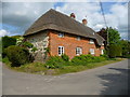
Stanton St Bernard - Thatched Cottage
An impressive thatched cottage in the village.
Image: © Chris Talbot
Taken: 15 May 2010
0.01 miles
3
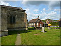
Stanton St Bernard - All Saints Church
The churchyard of All Saints Church.
Image: © Chris Talbot
Taken: 15 May 2010
0.02 miles
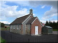
4
![Stanton St Bernard buildings [1]](https://s2.geograph.org.uk/geophotos/06/57/65/6576586_6f30236b_120x120.jpg)
Stanton St Bernard buildings [1]
This small former school, now the village hall was built in 1849. The school closed in 1970.
Stanton St Bernard is a small former agricultural village in the Vale of Pewsey about 6 miles east of Devizes. The parish includes Milk Hill, at 968 feet (295 metres) the highest point in Wiltshire.
Image: © Michael Dibb
Taken: 22 May 2020
0.03 miles
5
All Saints, Stanton St Bernard: church hall
Image: © Basher Eyre
Taken: 7 Oct 2014
0.03 miles
6
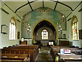
Stanton St Bernard - All Saints Church
The interior of All Saints Church.
Image: © Chris Talbot
Taken: 15 May 2010
0.03 miles
7
![Parish church [2]](https://s0.geograph.org.uk/geophotos/06/57/65/6576568_e2b756ae_120x120.jpg)
Parish church [2]
The Anglican parish church of All Saints has a late 15th/early 16th century tower with the nave, chancel, north porch and south vestry all rebuilt in 1832. Much of the interior fittings are early 19th century although the font is 12th century. Listed, grade II, with details at: https://historicengland.org.uk/listing/the-list/list-entry/1365968
Stanton St Bernard is a small former agricultural village in the Vale of Pewsey about 6 miles east of Devizes. The parish includes Milk Hill, at 968 feet (295 metres) the highest point in Wiltshire.
Image: © Michael Dibb
Taken: 22 May 2020
0.03 miles
8
![Stanton St Bernard houses [13]](https://s0.geograph.org.uk/geophotos/06/57/65/6576564_c2a7dc59_120x120.jpg)
Stanton St Bernard houses [13]
One of two blocks of semi-detached cottages, numbers 1 and 2 Church Walk are former estate cottages with distinctive round headed windows.
Stanton St Bernard is a small former agricultural village in the Vale of Pewsey about 6 miles east of Devizes. The parish includes Milk Hill, at 968 feet (295 metres) the highest point in Wiltshire.
Image: © Michael Dibb
Taken: 22 May 2020
0.03 miles
9
![Parish church [1]](https://s3.geograph.org.uk/geophotos/06/57/65/6576567_bcc41d85_120x120.jpg)
Parish church [1]
The Anglican parish church of All Saints has a late 15th/early 16th century tower with the nave, chancel, north porch and south vestry all rebuilt in 1832. Much of the interior fittings are early 19th century although the font is 12th century. Listed, grade II, with details at: https://historicengland.org.uk/listing/the-list/list-entry/1365968
Stanton St Bernard is a small former agricultural village in the Vale of Pewsey about 6 miles east of Devizes. The parish includes Milk Hill, at 968 feet (295 metres) the highest point in Wiltshire.
Image: © Michael Dibb
Taken: 22 May 2020
0.04 miles
10
![Parish church [3]](https://s2.geograph.org.uk/geophotos/06/57/65/6576570_a3d7995e_120x120.jpg)
Parish church [3]
This fine group of 18th century monuments in limestone to various members of the Pile family are listed, grade II, with details at: https://historicengland.org.uk/listing/the-list/list-entry/1193949
Image: © Michael Dibb
Taken: 22 May 2020
0.04 miles