1
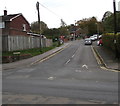
Marlborough (High Level) railway station (site), Wiltshire
Opened in 1864 by the Great Western Railway as the terminus of a short branch line from Savernake, this station closed to passengers in 1933 and completely in 1964. Passenger services were transferred to the Marlborough Low Level station (see
Image) some 10 years after they had taken control of both stations.
View south west along the site of the platform, away from the buffers. The site is now in the middle of a housing estate.
Image: © Nigel Thompson
Taken: 14 Mar 2019
0.05 miles
2
2010 : A346 Salisbury Road, about to leave Marlborough
On the way to Burbage.
Image: © Maurice Pullin
Taken: 8 Sep 2010
0.10 miles
3
2010 : A346 entering Marlborough on Salisbury Road
Although named "Salisbury Road" long before "A" roads were thought of the A346 only gets as far as the A338 at Burbage.
Old red brick cottages on the left are typical of the area and far easier on the eye than their modern counterpart opposite (though I know which one I would rather live in).
Image: © Maurice Pullin
Taken: 8 Sep 2010
0.13 miles
4
A346 Salisbury Road, Marlborough
Heading into town.
Image: © Robin Webster
Taken: 16 Sep 2018
0.13 miles
5
New roundabout on Salisbury Road, Marlborough
The roundabout is part of the infrastructure changes necessitated by the development of a business park south of Marlborough out of sight behind the viewpoint (but visible in other submissions). The Ordnance Survey have updated the 1:50K map but not the 1:25K edition.
Image: © Brian Robert Marshall
Taken: 24 Oct 2007
0.14 miles
6
Salisbury Road roundabout on the A346
Image: © Colin Pyle
Taken: 25 Oct 2014
0.15 miles
7
Site of Marlborough (Low Level) station, 2002
View southward on A346 road, past the abutments of the former railway bridge, the station having been on the right: ex-GWR (Midland & South Western Junction) line (Cheltenham) - Andoversford Junction - Swindon Town - Marlborough - Savernake - Andover Junction. Most of the line was closed throughout from 11/9/61, but goods was worked Savernake - Marlborough until 7/9/64.
Image: © Ben Brooksbank
Taken: 3 Sep 2002
0.15 miles
8
New housing in Marlborough
On the southern edge of the town
Image: © Neil Theasby
Taken: 14 Jun 2022
0.15 miles
9
2010 : House at Priorsfield, Marlborough
Off the A346 Salisbury Road.
Image: © Maurice Pullin
Taken: 8 Sep 2010
0.15 miles
10
Ducks Meadow, Marlborough
The dead end road Ducks Meadow ascends from the B3052 George Lane.
Image: © Jaggery
Taken: 14 Oct 2017
0.15 miles


