
IMAGES TAKEN NEAR TO
Salisbury Road, MARLBOROUGH, SN8 4AH
Introduction
This page details the photographs taken nearby to Salisbury Road, SN8 4AH by members of the Geograph project.
The Geograph project started in 2005 with the aim of publishing, organising and preserving representative images for every square kilometre of Great Britain, Ireland and the Isle of Man.

There are currently over 7.5m images from over14,400 individuals and you can help contribute to the project by visiting https://www.geograph.org.uk
Image Map
Images are licensed for reuse under creativecommons.org/licenses/by-sa/2.0
Notes
- Clicking on the map will re-center to the selected point.
- The higher the marker number, the further away the image location is from the centre of the postcode.
Image Listing (279 Images Found)
Images are licensed for reuse under creativecommons.org/licenses/by-sa/2.0
Image
Details
Distance
1
![Marlborough houses [89]](https://s0.geograph.org.uk/geophotos/06/99/21/6992136_ca7100a6_120x120.jpg)
Marlborough houses [89]
Number 4 George Street is the former coach house to Linden Lodge Image Constructed in the early 19th century of flint with red brick dressings under a slate roof. Listed, grade II, with details at: https://historicengland.org.uk/listing/the-list/list-entry/1243242
Marlborough is a market town on the Old Bath Road once the main road from London to Bath. The twice-weekly market is sited in High Street, one of the widest in England, lined on both sides with fine listed buildings of which the town has almost 300. There is evidence of local settlement from every period from the prehistoric to the present day. The town is home to the renowned Marlborough College. The River Kennet flows through the town.
Image: © Michael Dibb
Taken: 11 Jun 2021
0.03 miles
2
![Marlborough houses [91]](https://s1.geograph.org.uk/geophotos/06/99/21/6992141_31f49e39_120x120.jpg)
Marlborough houses [91]
Elizabethan House, number 8 George Lane, was built in the 18th century. Constructed of flint with brick dressings and quoins, under a thatched roof. Listed, grade II, with details at: https://historicengland.org.uk/listing/the-list/list-entry/1034275
Marlborough is a market town on the Old Bath Road once the main road from London to Bath. The twice-weekly market is sited in High Street, one of the widest in England, lined on both sides with fine listed buildings of which the town has almost 300. There is evidence of local settlement from every period from the prehistoric to the present day. The town is home to the renowned Marlborough College. The River Kennet flows through the town.
Image: © Michael Dibb
Taken: 11 Jun 2021
0.03 miles
3
![Marlborough houses [90]](https://s3.geograph.org.uk/geophotos/06/99/21/6992139_61824ec6_120x120.jpg)
Marlborough houses [90]
Numbers 5 to 7 George Lane are a row of 16th century cottages with later rear extensions. Timber framed with brick noggin and some plaster, all under a thatched roof. Listed, grade II, with details at: https://historicengland.org.uk/listing/the-list/list-entry/1034274
Marlborough is a market town on the Old Bath Road once the main road from London to Bath. The twice-weekly market is sited in High Street, one of the widest in England, lined on both sides with fine listed buildings of which the town has almost 300. There is evidence of local settlement from every period from the prehistoric to the present day. The town is home to the renowned Marlborough College. The River Kennet flows through the town.
Image: © Michael Dibb
Taken: 11 Jun 2021
0.03 miles
4

Thatched cottages on George Lane
The larger cottage is an eighteenth century building, which sits cosily with the row of single storey cottages - of sixteenth century age. These form a group of important buildings on George Lane and are all Grade II listed.
Image: © Neil Owen
Taken: 1 Jul 2025
0.03 miles
5
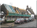
Re-thatching Nos. 5-7 George Lane Marlborough
A terrace of C16th Grade II Listed cottages https://historicengland.org.uk/listing/the-list/list-entry/1034274 .
Image: © Rod Allday
Taken: 6 Mar 2013
0.03 miles
6
![Marlborough houses [15]](https://s2.geograph.org.uk/geophotos/05/49/17/5491770_dff99fb7_120x120.jpg)
Marlborough houses [15]
The three blocks of buildings seen here in George Lane (B3052) are all listed. Numbers 1-3 are 18th century brick and stone. Numbers 5-7 are 16th century timber framed. Number 8 is 18th century flint. More details are at: https://www.historicengland.org.uk/listing/the-list/list-entry/1252942 https://www.historicengland.org.uk/listing/the-list/list-entry/1034274 and https://www.historicengland.org.uk/listing/the-list/list-entry/1034275
Marlborough is a market town on the Old Bath Road once the main road from London to Bath. The twice-weekly market is sited in High Street, one of the widest in England, lined on both sides with fine listed buildings of which the town has almost 300. There is evidence of local settlement from every period from the prehistoric to the present day. The town is home to the renowned Marlborough College. The River Kennet flows through the town.
Image: © Michael Dibb
Taken: 17 Jul 2017
0.03 miles
7
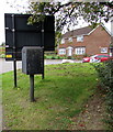
Royal Mail drop box on a Marlborough corner
On the corner of Culvermead Close and the B3052 George Lane.
Image: © Jaggery
Taken: 14 Oct 2017
0.04 miles
8
![Marlborough houses [92]](https://s3.geograph.org.uk/geophotos/06/99/21/6992143_bb41a7f7_120x120.jpg)
Marlborough houses [92]
Linden Lodge, number 21 Salisbury Road, was built in the early 19th century. Constructed of flint with red brick dressings and quoins. The front is rendered and lined to simulate ashlar, all under a hipped slate roof. Listed, grade II, with details at: https://historicengland.org.uk/listing/the-list/list-entry/1272926
Marlborough is a market town on the Old Bath Road once the main road from London to Bath. The twice-weekly market is sited in High Street, one of the widest in England, lined on both sides with fine listed buildings of which the town has almost 300. There is evidence of local settlement from every period from the prehistoric to the present day. The town is home to the renowned Marlborough College. The River Kennet flows through the town.
Image: © Michael Dibb
Taken: 11 Jun 2021
0.04 miles
9

St Thomas More Catholic Church
Marlborough is not known for being kind to motorists. They have had to contend with formerly high fuel prices and strangely shaped parking spaces Image Now, since the removal of much free parking in the town centre a few years ago, ordinary car parks and spaces are jealously guarded, in this case with a barrier and a firmly worded notice.
The church, one of the furthest-flung outposts of the Diocese of Clifton, 'was built in 1959 (datestone in east wall). The identity of the architect has not been established, but the design is a more modern version of the reinforced concrete-framed designs built in and around Swindon in the 1950s by R. J. Beswick & Son.' https://taking-stock.org.uk/building/marlborough-st-thomas-more/
Beyond the church can be seen the B3052, busy today because the High Street was closed.
Image: © HelenK
Taken: 4 Oct 2025
0.04 miles
10
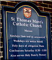
Information board, St Thomas More's Catholic Church, George Lane, Marlborough
On a wall of this http://www.geograph.org.uk/photo/5570607 church.
Image: © Jaggery
Taken: 14 Oct 2017
0.04 miles