IMAGES TAKEN NEAR TO
Cherry Orchard, MARLBOROUGH, SN8 4AF
Introduction
This page details the photographs taken nearby to Cherry Orchard, SN8 4AF by members of the Geograph project.
The Geograph project started in 2005 with the aim of publishing, organising and preserving representative images for every square kilometre of Great Britain, Ireland and the Isle of Man.

There are currently over 7.5m images from over14,400 individuals and you can help contribute to the project by visiting https://www.geograph.org.uk
Image Map
Images are licensed for reuse under creativecommons.org/licenses/by-sa/2.0
Notes
- Clicking on the map will re-center to the selected point.
- The higher the marker number, the further away the image location is from the centre of the postcode.
Image Listing (108 Images Found)
Images are licensed for reuse under creativecommons.org/licenses/by-sa/2.0
Image
Details
Distance
1
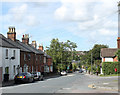
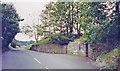
2010 : A346 entering Marlborough on Salisbury Road
Although named "Salisbury Road" long before "A" roads were thought of the A346 only gets as far as the A338 at Burbage.
Old red brick cottages on the left are typical of the area and far easier on the eye than their modern counterpart opposite (though I know which one I would rather live in).
Image: © Maurice Pullin
Taken: 8 Sep 2010
0.05 miles
2
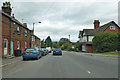
A346 Salisbury Road, Marlborough
Heading into town.
Image: © Robin Webster
Taken: 16 Sep 2018
0.06 miles
3
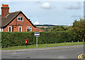
2010 : House at Priorsfield, Marlborough
Off the A346 Salisbury Road.
Image: © Maurice Pullin
Taken: 8 Sep 2010
0.07 miles
4
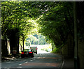
2010 : A346 Salisbury Road, about to leave Marlborough
On the way to Burbage.
Image: © Maurice Pullin
Taken: 8 Sep 2010
0.08 miles
5
![Recreation ground [3]](https://s0.geograph.org.uk/geophotos/05/47/11/5471116_e83f7061_120x120.jpg)
Recreation ground [3]
Part of the play area at Salisbury Road Recreation Ground.
Image: © Michael Dibb
Taken: 17 Jul 2017
0.08 miles
6
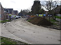
Site of Marlborough (Low Level) station, 2002
View southward on A346 road, past the abutments of the former railway bridge, the station having been on the right: ex-GWR (Midland & South Western Junction) line (Cheltenham) - Andoversford Junction - Swindon Town - Marlborough - Savernake - Andover Junction. Most of the line was closed throughout from 11/9/61, but goods was worked Savernake - Marlborough until 7/9/64.
Image: © Ben Brooksbank
Taken: 3 Sep 2002
0.11 miles
7
Marlborough (High Level) railway station (site), Wiltshire
Opened in 1864 by the Great Western Railway as the terminus of a short branch line from Savernake, this station closed to passengers in 1933 and completely in 1964. Passenger services were transferred to the Marlborough Low Level station (see Image) some 10 years after they had taken control of both stations.
View south west along the site of the platform, away from the buffers. The site is now in the middle of a housing estate.
Image: © Nigel Thompson
Taken: 14 Mar 2019
0.12 miles
8
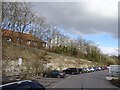
Marlborough (Low Level) railway station (site), Wiltshire
Opened in 1881 by the Swindon Marlborough and Andover Railway, later part of the Midland & South Western Junction Railway, this station closed to passengers in 1961 and completely in 1964.
View east towards Ogbourne and Marlborough. The station platforms were at a higher level to the left, and the ground level appears to have been lowered to make the current supermarket car-park.
Image: © Nigel Thompson
Taken: 14 Mar 2019
0.12 miles
9
![Marlborough houses [89]](https://s0.geograph.org.uk/geophotos/06/99/21/6992136_ca7100a6_120x120.jpg)
Marlborough houses [89]
Number 4 George Street is the former coach house to Linden Lodge Image Constructed in the early 19th century of flint with red brick dressings under a slate roof. Listed, grade II, with details at: https://historicengland.org.uk/listing/the-list/list-entry/1243242
Marlborough is a market town on the Old Bath Road once the main road from London to Bath. The twice-weekly market is sited in High Street, one of the widest in England, lined on both sides with fine listed buildings of which the town has almost 300. There is evidence of local settlement from every period from the prehistoric to the present day. The town is home to the renowned Marlborough College. The River Kennet flows through the town.
Image: © Michael Dibb
Taken: 11 Jun 2021
0.13 miles
10
![Marlborough houses [92]](https://s3.geograph.org.uk/geophotos/06/99/21/6992143_bb41a7f7_120x120.jpg)
Marlborough houses [92]
Linden Lodge, number 21 Salisbury Road, was built in the early 19th century. Constructed of flint with red brick dressings and quoins. The front is rendered and lined to simulate ashlar, all under a hipped slate roof. Listed, grade II, with details at: https://historicengland.org.uk/listing/the-list/list-entry/1272926
Marlborough is a market town on the Old Bath Road once the main road from London to Bath. The twice-weekly market is sited in High Street, one of the widest in England, lined on both sides with fine listed buildings of which the town has almost 300. There is evidence of local settlement from every period from the prehistoric to the present day. The town is home to the renowned Marlborough College. The River Kennet flows through the town.
Image: © Michael Dibb
Taken: 11 Jun 2021
0.13 miles