IMAGES TAKEN NEAR TO
The Withies, MARLBOROUGH, SN8 3TT
Introduction
This page details the photographs taken nearby to The Withies, SN8 3TT by members of the Geograph project.
The Geograph project started in 2005 with the aim of publishing, organising and preserving representative images for every square kilometre of Great Britain, Ireland and the Isle of Man.

There are currently over 7.5m images from over14,400 individuals and you can help contribute to the project by visiting https://www.geograph.org.uk
Image Map (Loading...)


Getting Data...Please wait
Leaflet Map data © OpenStreetMap
Images are licensed for reuse under creativecommons.org/licenses/by-sa/2.0
Notes
- Clicking on the map will re-center to the selected point.
- The higher the marker number, the further away the image location is from the centre of the postcode.
Image Listing (27 Images Found)
Images are licensed for reuse under creativecommons.org/licenses/by-sa/2.0
Image
Details
Distance
1
![Burbage houses [4]](https://s1.geograph.org.uk/geophotos/07/39/38/7393821_827f5d3d_120x120.jpg)
Burbage houses [4]
Numbers 30 and 32 High Street are two cottages in a block. Number 30, on the right, is probably 17th century, number 32 was added later. Constructed of rendered brick under a thatch roof. Both cottages have lean to extensions at the rear. Listed, grade II, with details at: https://historicengland.org.uk/listing/the-list/list-entry/1035918
Burbage is a village in the Vale of Pewsey, Wiltshire, it lies about 5½ miles southeast of Marlborough and some 15½ miles west of Newbury. The narrow village High Street was the main north to south road from Marlborough to Andover (A346) until a bypass was built to the west in 1991. Settlement can be traced back to the Neolithic period, and Bronze Age artefacts have been found. Burbage is now essentially a commuter village.
Image: © Michael Dibb
Taken: 23 Jan 2023
0.03 miles
2
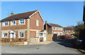
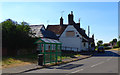
The Withies, Stibb Green
A short residential cul de sac off the High Street.
Image: © Des Blenkinsopp
Taken: 27 Feb 2019
0.03 miles
3
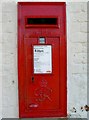
Burbage postbox
At least 55 years old.
Image: © Brian Robert Marshall
Taken: 3 Feb 2007
0.07 miles
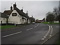
4
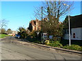
The road to Durley and Savernake from Burbage
The road crosses the railway from London to the southwest and the Kennet and Avon canal about a kilometre north-east of this point.
Image: © Brian Robert Marshall
Taken: 3 Feb 2007
0.10 miles
5
![Burbage houses [5]](https://s0.geograph.org.uk/geophotos/07/39/38/7393824_cd12d05a_120x120.jpg)
Burbage houses [5]
Meadowview Cottage, number 54 High Street, was built in the early or mid 18th century. Constructed of painted brick under a thatch roof. There is an extension at the rear. Listed, grade II, with details at: https://historicengland.org.uk/listing/the-list/list-entry/1035919
Burbage is a village in the Vale of Pewsey, Wiltshire, it lies about 5½ miles southeast of Marlborough and some 15½ miles west of Newbury. The narrow village High Street was the main north to south road from Marlborough to Andover (A346) until a bypass was built to the west in 1991. Settlement can be traced back to the Neolithic period, and Bronze Age artefacts have been found. Burbage is now essentially a commuter village.
Image: © Michael Dibb
Taken: 23 Jan 2023
0.11 miles
6
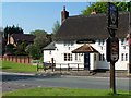
What was the Three Horseshoes, Stibb Green, Burbage
It appears that the once-thriving village pub has been closed up and sold by the former owners, Wadworth Brewery of Devizes http://www.gazetteandherald.co.uk/news/16124675.Village_vows_to_fight_for_its_pub/ Seems a shame. I remember it as a popular gastro pub long before the term was invented. As it looked a decade ago Image
Image: © Brian Robert Marshall
Taken: 10 Jul 2018
0.12 miles
8
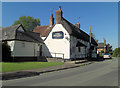
The Three Horse Shoes, Stibb Green
This is a gem of a pub. I wish it was my local, just because of the welcoming landlord.
Image: © Stuart Logan
Taken: 29 Sep 2011
0.12 miles
9
![Burbage buildings [1]](https://s3.geograph.org.uk/geophotos/07/39/31/7393127_ef7a88c1_120x120.jpg)
Burbage buildings [1]
Number 1 Stibb Green was formerly The Three Horseshoes public house. Built in the 19th century of brick under a thatch roof. Closed in 2017, the building has had planning permission for conversion to housing refused and there is a local campaign to make it into a community pub.
Burbage is a village in the Vale of Pewsey, Wiltshire, it lies about 5½ miles southeast of Marlborough and some 15½ miles west of Newbury. The narrow village High Street was the main north to south road from Marlborough to Andover (A346) until a bypass was built to the west in 1991. Settlement can be traced back to the Neolithic period, and Bronze Age artefacts have been found. Burbage is now essentially a commuter village.
Image: © Michael Dibb
Taken: 23 Jan 2023
0.12 miles