IMAGES TAKEN NEAR TO
Aughton, MARLBOROUGH, SN8 3RZ
Introduction
This page details the photographs taken nearby to Aughton, SN8 3RZ by members of the Geograph project.
The Geograph project started in 2005 with the aim of publishing, organising and preserving representative images for every square kilometre of Great Britain, Ireland and the Isle of Man.

There are currently over 7.5m images from over14,400 individuals and you can help contribute to the project by visiting https://www.geograph.org.uk
Image Map (Loading...)


Getting Data...Please wait
Leaflet Map data © OpenStreetMap
Images are licensed for reuse under creativecommons.org/licenses/by-sa/2.0
Notes
- Clicking on the map will re-center to the selected point.
- The higher the marker number, the further away the image location is from the centre of the postcode.
Image Listing (14 Images Found)
Images are licensed for reuse under creativecommons.org/licenses/by-sa/2.0
Image
Details
Distance
1
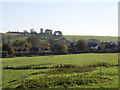
Approaching Aughton
On the footpath south of Aughton Farm.
Image: © Andrew Smith
Taken: 4 Nov 2006
0.03 miles
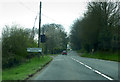
2
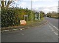
Aughton, bus shelter
On A338; served by services from Marlborough to Ludgershall.
Image: © Mike Faherty
Taken: 4 Jan 2017
0.08 miles
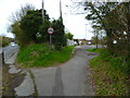
3
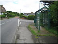
Aughton: A338 and Aughton bus stop and shelter
Ham Close is on the right.
Image: © Nigel Cox
Taken: 12 Jul 2009
0.10 miles
4
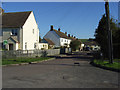
Ham Close, Aughton
One of two cul-de-sacs of modern houses to the south of the hamlet.
Image: © Andrew Smith
Taken: 4 Nov 2006
0.15 miles
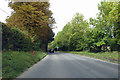
5
A338 at Aughton
Approaching Collingbourne Kingston
Image: © Chris Gunns
Taken: 6 Apr 2019
0.15 miles
6
The Orange Way in Wiltshire (325)
The Orange Way turns east from the A338 at Aughton.
Image: © Shazz
Taken: 28 Apr 2013
0.16 miles
8
Milestone, Aughton
Early 19th century milestone with Ordnance Survey rivet in the top. For a wider view Image
Image: © Maigheach-gheal
Taken: 5 Mar 2011
0.20 miles
9
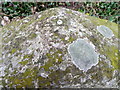
Bench mark on milestone, Aughton
The Ordnance Survey bench mark on milestone. For a wider view Image and for further information on the bench mark and others in the area http://www.bench-marks.org.uk/bm37377
Image: © Maigheach-gheal
Taken: 5 Mar 2011
0.20 miles
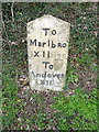
10
Old Milestone by the A338, Aughton
Carved stone post by the A338, in parish of COLLINGBOURNE KINGSTON (KENNET District), Aughton, northern edge of Collingbourne Kingston, just past lay-by, in bank under hedge, behind tarmac path, on West side of road. Marlborough gable, erected by the Marlborough & Salisbury Turnpike Trust in the 18th century.
Inscription reads:-
To
Marlbro'
XII Miles
To
Andover XII
Carved bench mark and rivet on top.
Grade II Listed. List Entry Number: 1180778
https://historicengland.org.uk/listing/the-list/list-entry/1180778
Milestone Society National ID: WI_MLAV08.
Image: © Milestone Society
Taken: 4 Jan 2017
0.20 miles