IMAGES TAKEN NEAR TO
Shalbourne, MARLBOROUGH, SN8 3RW
Introduction
This page details the photographs taken nearby to SN8 3RW by members of the Geograph project.
The Geograph project started in 2005 with the aim of publishing, organising and preserving representative images for every square kilometre of Great Britain, Ireland and the Isle of Man.

There are currently over 7.5m images from over14,400 individuals and you can help contribute to the project by visiting https://www.geograph.org.uk
Image Map (Loading...)


Getting Data...Please wait
Leaflet Map data © OpenStreetMap
Images are licensed for reuse under creativecommons.org/licenses/by-sa/2.0
Notes
- Clicking on the map will re-center to the selected point.
- The higher the marker number, the further away the image location is from the centre of the postcode.
Image Listing (9 Images Found)
Images are licensed for reuse under creativecommons.org/licenses/by-sa/2.0
Image
Details
Distance
1
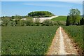
Farmland, Shalbourne
A footpath descending through wheat into the valley of the Shalbourne Brook with a copse on the hillside beyond the A338.
Image: © Andrew Smith
Taken: 30 May 2021
0.06 miles
2
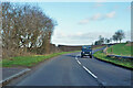
A338 towards Hungerford
In the foreground crossing the Shalbourne Brook.
Image: © Robin Webster
Taken: 13 Jan 2023
0.07 miles
3
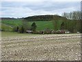
Farmland, Shalbourne
Looking over a pair of houses on the A338. Just the nearest corner of the plantation is within this grid-square.
Image: © Andrew Smith
Taken: 5 Apr 2008
0.07 miles
4
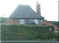
Oakhill Cottage, Shalbourne
A charmingly idiosyncratic thatched cottage visible to the motorist as they leave the village. Redolent of a character in a child's fairy story, it peeps over its hedge to see who's coming up the road.
Image: © Stuart Logan
Taken: 26 Jul 2011
0.14 miles
5
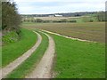
Track and farmland, Shalbourne
At the edge of Baverstock's Copse. The farm buildings are on the A338 south of Lower Slope End Farm.
Image: © Andrew Smith
Taken: 5 Apr 2008
0.15 miles
6
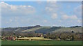
View over farmland to Ham Hill, Wiltshire
Image: © Edmund Shaw
Taken: 6 Apr 2015
0.16 miles
7
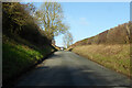
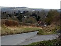
Mill Lane climbs out of Shalbourne
Up to join the A338, on a ridge here. The mill of the road's name was a watermill, the road is climbing away from it. There was also a windmill on top of the ridge, further west.
Image: © Robin Webster
Taken: 13 Jan 2023
0.16 miles
8
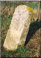
Old Milestone by the A338, Shalbourne
Hungerford tombstone by the A338, in parish of Shalbourne (Kennet District), Eastcourt Farm, between Bagshot turn and new bridge, on grass bank in front of hedge.
Inscription once read:-
(HUNGERFORD)
(3)
(SARUM)
(34)
Rivet bench mark on top.
Grade II listed.
List Entry Number: 1300100 https://historicengland.org.uk/listing/the-list/list-entry/1300100
Surveyed
Milestone Society National ID: WI_hgsa03
Image: © Milestone Society
Taken: Unknown
0.17 miles