IMAGES TAKEN NEAR TO
Ham Spray, MARLBOROUGH, SN8 3QZ
Introduction
This page details the photographs taken nearby to SN8 3QZ by members of the Geograph project.
The Geograph project started in 2005 with the aim of publishing, organising and preserving representative images for every square kilometre of Great Britain, Ireland and the Isle of Man.

There are currently over 7.5m images from over14,400 individuals and you can help contribute to the project by visiting https://www.geograph.org.uk
Image Map (Loading...)


Getting Data...Please wait
Leaflet Map data © OpenStreetMap
Images are licensed for reuse under creativecommons.org/licenses/by-sa/2.0
Notes
- Clicking on the map will re-center to the selected point.
- The higher the marker number, the further away the image location is from the centre of the postcode.
Image Listing (6 Images Found)
Images are licensed for reuse under creativecommons.org/licenses/by-sa/2.0
Image
Details
Distance
1
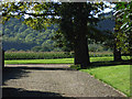
Garden, Ham Spray
To the west of Garden Cottage, which is on the south side of Spray Road to the east of Lower Spray Farm. More of the ubiquitous maize with Rivar Copse on the down beyond.
Image: © Andrew Smith
Taken: 17 Sep 2006
0.07 miles
2
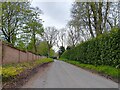
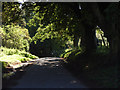
Spray Road narrows
Spray Road narrows in Lower Spray Copse. In this direction the road leads to Ham.
Image: © Oscar Taylor
Taken: 30 Apr 2023
0.09 miles
3
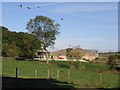
Lower Spray Farm
Viewed from nearby cottages on Spray Road
Image: © Andrew Smith
Taken: 17 Sep 2006
0.16 miles
4
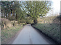
Spray Road passes south of Cowleys Copse
Image: © Stuart Logan
Taken: 5 Mar 2013
0.17 miles
5
Spray Road
Next to Cowley's Copse between Ham Spray and Lower Spray Farms.
Image: © Andrew Smith
Taken: 17 Sep 2006
0.20 miles
6
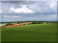
Land art south of Inkpen
The farmer has ploughed part of this field recently (the chalky-white section) but the rest of the field, now red with poppies, was cultivated last autumn and left for set-aside. In the foreground is a barley crop sown last autumn.
Image: © Mick Crawley
Taken: 9 May 2004
0.24 miles