IMAGES TAKEN NEAR TO
Kew Gardens, MARLBOROUGH, SN8 3QW
Introduction
This page details the photographs taken nearby to Kew Gardens, SN8 3QW by members of the Geograph project.
The Geograph project started in 2005 with the aim of publishing, organising and preserving representative images for every square kilometre of Great Britain, Ireland and the Isle of Man.

There are currently over 7.5m images from over14,400 individuals and you can help contribute to the project by visiting https://www.geograph.org.uk
Image Map
Images are licensed for reuse under creativecommons.org/licenses/by-sa/2.0
Notes
- Clicking on the map will re-center to the selected point.
- The higher the marker number, the further away the image location is from the centre of the postcode.
Image Listing (3 Images Found)
Images are licensed for reuse under creativecommons.org/licenses/by-sa/2.0
Image
Details
Distance
1
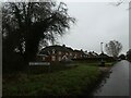
A less famous Kew Gardens
(this one is in Shalbourne, Wiltshire)
Image: © Basher Eyre
Taken: 28 Dec 2024
0.04 miles
2
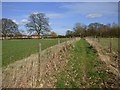
Footpath through pasture, Shalbourne
The footpath is omitted from the Ordnance Suvery's 1:50000 map, but is clear and easily followed as it approaches the eastern end of a row of houses on Ham Road.
Image: © Andrew Smith
Taken: 11 Mar 2019
0.08 miles
3

Looking North East from Ham Road
The Houses are in Cutting Hill (lane) , as it drops into the village of Ham
Image: © Colin Bates
Taken: 4 Jan 2006
0.08 miles