IMAGES TAKEN NEAR TO
Severalls, MARLBOROUGH, SN8 3QU
Introduction
This page details the photographs taken nearby to Severalls, SN8 3QU by members of the Geograph project.
The Geograph project started in 2005 with the aim of publishing, organising and preserving representative images for every square kilometre of Great Britain, Ireland and the Isle of Man.

There are currently over 7.5m images from over14,400 individuals and you can help contribute to the project by visiting https://www.geograph.org.uk
Image Map
Images are licensed for reuse under creativecommons.org/licenses/by-sa/2.0
Notes
- Clicking on the map will re-center to the selected point.
- The higher the marker number, the further away the image location is from the centre of the postcode.
Image Listing (3 Images Found)
Images are licensed for reuse under creativecommons.org/licenses/by-sa/2.0
Image
Details
Distance
1
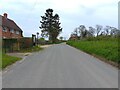
Spray Road
Spray Road on the edge of Ham, looking towards Lower Green.
Image: © Oscar Taylor
Taken: 30 Apr 2023
0.02 miles
2
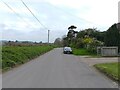
Spray Road
Spray Road on the edge of Ham, looking towards Ham.
Image: © Oscar Taylor
Taken: 30 Apr 2023
0.03 miles
3
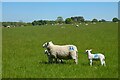
Pasture, Ham
Ewes and lambs beside a footpath to the north of the village.
Image: © Andrew Smith
Taken: 30 May 2021
0.14 miles