IMAGES TAKEN NEAR TO
Shalbourne, MARLBOROUGH, SN8 3NF
Introduction
This page details the photographs taken nearby to SN8 3NF by members of the Geograph project.
The Geograph project started in 2005 with the aim of publishing, organising and preserving representative images for every square kilometre of Great Britain, Ireland and the Isle of Man.

There are currently over 7.5m images from over14,400 individuals and you can help contribute to the project by visiting https://www.geograph.org.uk
Image Map
Images are licensed for reuse under creativecommons.org/licenses/by-sa/2.0
Notes
- Clicking on the map will re-center to the selected point.
- The higher the marker number, the further away the image location is from the centre of the postcode.
Image Listing (4 Images Found)
Images are licensed for reuse under creativecommons.org/licenses/by-sa/2.0
Image
Details
Distance
1
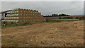
Starveall
The trees are at Piccadilly crossroads.
Image: © Andrew Smith
Taken: 17 Sep 2006
0.03 miles
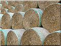
3
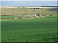
Farmland, Shalbourne
Looking down to Starveall Farm, on the grid-square's southern boundary. The backdrop is Rivar Down.
Image: © Andrew Smith
Taken: 5 Apr 2008
0.03 miles
4
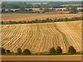
A closer look at farmland east of Marten
The hedge in the foreground and much of the field the other side of it is in this square. The hedge in the distance is in the next square east.
Image: © Brian Robert Marshall
Taken: 26 Sep 2008
0.17 miles