IMAGES TAKEN NEAR TO
Lower Horsehall Hill, MARLBOROUGH, SN8 3HX
Introduction
This page details the photographs taken nearby to Lower Horsehall Hill, SN8 3HX by members of the Geograph project.
The Geograph project started in 2005 with the aim of publishing, organising and preserving representative images for every square kilometre of Great Britain, Ireland and the Isle of Man.

There are currently over 7.5m images from over14,400 individuals and you can help contribute to the project by visiting https://www.geograph.org.uk
Image Map
Images are licensed for reuse under creativecommons.org/licenses/by-sa/2.0
Notes
- Clicking on the map will re-center to the selected point.
- The higher the marker number, the further away the image location is from the centre of the postcode.
Image Listing (5 Images Found)
Images are licensed for reuse under creativecommons.org/licenses/by-sa/2.0
Image
Details
Distance
1
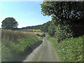
Un-named lane southwest of Upper Horsehall Hill Farm
Image: © Stuart Logan
Taken: 24 Jul 2012
0.08 miles
2
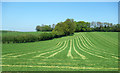
Stripey Mowing
Hay crop at Upper Horsehall Hill Farm.
Image: © Des Blenkinsopp
Taken: 8 May 2018
0.08 miles
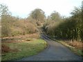
4
Pasture, Chisbury
Looking down across fields from the bridleway near Chisbury Lane Farm.
Image: © Andrew Smith
Taken: 21 Mar 2008
0.16 miles
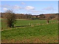
5

Remains of a Hedgerow
The hedge has mostly gone, but a line of bluebells is still there by the footpath.
Image: © Des Blenkinsopp
Taken: 8 May 2018
0.20 miles