IMAGES TAKEN NEAR TO
Everleigh, MARLBOROUGH, SN8 3HD
Introduction
This page details the photographs taken nearby to SN8 3HD by members of the Geograph project.
The Geograph project started in 2005 with the aim of publishing, organising and preserving representative images for every square kilometre of Great Britain, Ireland and the Isle of Man.

There are currently over 7.5m images from over14,400 individuals and you can help contribute to the project by visiting https://www.geograph.org.uk
Image Map (Loading...)


Getting Data...Please wait
Leaflet Map data © OpenStreetMap
Images are licensed for reuse under creativecommons.org/licenses/by-sa/2.0
Notes
- Clicking on the map will re-center to the selected point.
- The higher the marker number, the further away the image location is from the centre of the postcode.
Image Listing (6 Images Found)
Images are licensed for reuse under creativecommons.org/licenses/by-sa/2.0
Image
Details
Distance
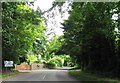
2
The Orange Way in Wiltshire (303)
The trees beyond the A342 can be seen. On the left is an old sign for a public telephone.
Image: © Shazz
Taken: 25 Apr 2013
0.13 miles
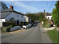
3
The Orange Way in Wiltshire (304)
This is looking back to a glimpse of "The Crown" PH at Everleigh.
Image: © Shazz
Taken: 25 Apr 2013
0.17 miles
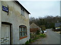
4
East Everleigh
The main population centre of Everleigh. Not a picture postcard village, just a few older cottages.
Image: © Andrew Smith
Taken: 6 Apr 2007
0.19 miles
5
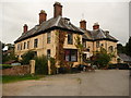
Everleigh - The Crown Hotel
This establishment was once a dower house, a dower house is where the widow of an estate owner would live so that the inheritor of the estate could move into the main house.
Image: © Chris Talbot
Taken: 23 Aug 2009
0.20 miles
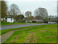
6
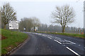
A342 towards Andover
A few flakes of snow were falling.
Image: © Robin Webster
Taken: 17 Mar 2018
0.22 miles