IMAGES TAKEN NEAR TO
Everleigh Road, MARLBOROUGH, SN8 3FE
Introduction
This page details the photographs taken nearby to Everleigh Road, SN8 3FE by members of the Geograph project.
The Geograph project started in 2005 with the aim of publishing, organising and preserving representative images for every square kilometre of Great Britain, Ireland and the Isle of Man.

There are currently over 7.5m images from over14,400 individuals and you can help contribute to the project by visiting https://www.geograph.org.uk
Image Map (Loading...)


Getting Data...Please wait
Leaflet Map data © OpenStreetMap
Images are licensed for reuse under creativecommons.org/licenses/by-sa/2.0
Notes
- Clicking on the map will re-center to the selected point.
- The higher the marker number, the further away the image location is from the centre of the postcode.
Image Listing (85 Images Found)
Images are licensed for reuse under creativecommons.org/licenses/by-sa/2.0
Image
Details
Distance
2
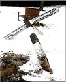
Old Direction Sign - Signpost by the A338,
Pyramid top finial - 3 arms; Wilts. wooden by the A338, in parish of Collingbourne Ducis (Kennet District), junction of Everleigh Road with Church Street/Tidworth Road, on grassy corner, near bench.
To be surveyed
Milestone Society National ID: WI_SU2453
Image: © Milestone Society
Taken: Unknown
0.08 miles
3
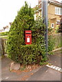
Collingbourne Ducis: postbox № SN8 67, Church Street
This little postbox stands virtually inside a shrub so that it looks almost as if it has grown here. It is emptied finally at 4:15pm on weekdays (it's about that time now and the collection has just been made) and at 8:00am on Saturdays.
Image: © Chris Downer
Taken: 1 Jun 2010
0.10 miles
4
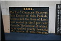
Generous Benefactor
Sign inside the belltower, small change now.
Image: © Bill Nicholls
Taken: 20 Apr 2008
0.11 miles
5
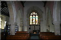
Bell Tower End
Church towards the bell tower, you can see the bell ropes hanging down.
Image: © Bill Nicholls
Taken: 20 Apr 2008
0.11 miles
6
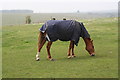
Lone horse
Lone horse munching on grass behind the farm just off the footpath.
Image: © Bill Nicholls
Taken: 20 Apr 2008
0.11 miles
7
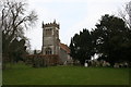
West end of St Andrews
View of the church from the new graveyard.
Image: © Bill Nicholls
Taken: 20 Apr 2008
0.11 miles
8
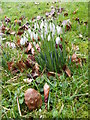
Snowdrops, St Andrew's Church
Snowdrops in the churchyard.
In sheltered places in south-west England the snowdrop begins to flower at Christmas, and in other parts it is welcomed as one of the first signs of spring, flowering from January to March.
The drooping, bell-shaped flowers have six segments - three white ones outside the flower and three tipped with a bright spot inside it.
It is doubtful whether the snowdrop (Galanthus nivalis) is a native of Britain. It was probably introduced in medieval times from central Europe and it is rare in Ireland.
Image: © Maigheach-gheal
Taken: 24 Jan 2011
0.12 miles
9
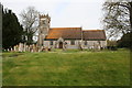
St Andrews Church
Side view of St Andrews.
Image: © Bill Nicholls
Taken: 20 Apr 2008
0.12 miles
10
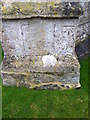
Bench Mark, St Andrew's Church
The bench mark is to be found on the south face of the church. For a view of the church Image and for further information on the bench mark and for others in the area http://www.bench-marks.org.uk/bm36644
Image: © Maigheach-gheal
Taken: 24 Jan 2011
0.12 miles