
IMAGES TAKEN NEAR TO
Ludgershall Road, MARLBOROUGH, SN8 3EJ
Introduction
This page details the photographs taken nearby to Ludgershall Road, SN8 3EJ by members of the Geograph project.
The Geograph project started in 2005 with the aim of publishing, organising and preserving representative images for every square kilometre of Great Britain, Ireland and the Isle of Man.

There are currently over 7.5m images from over14,400 individuals and you can help contribute to the project by visiting https://www.geograph.org.uk
Image Map
Images are licensed for reuse under creativecommons.org/licenses/by-sa/2.0
Notes
- Clicking on the map will re-center to the selected point.
- The higher the marker number, the further away the image location is from the centre of the postcode.
Image Listing (100 Images Found)
Images are licensed for reuse under creativecommons.org/licenses/by-sa/2.0
Image
Details
Distance
1
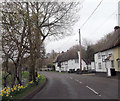
Thatched cottages on A346 at Collingbourne Ducis
Image: © John Firth
Taken: 17 Apr 2013
0.01 miles
2
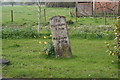
Leaning Milestone
This milestone does not seem to be marked on the map and the wording is painted.
Image: © Bill Nicholls
Taken: 20 Apr 2008
0.01 miles
3
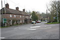
Cottages at the junction
These cottages would have been on a junction until the silly roundabout came.
Image: © Bill Nicholls
Taken: 20 Apr 2008
0.02 miles
4
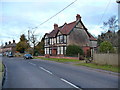
Collingbourne Ducis - Houses
The main road through Collingbourne Ducis.
Image: © Chris Talbot
Taken: 24 Jan 2009
0.03 miles
5
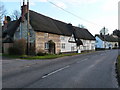
Collingbourne Ducis - Thatched Cottages
Thatched cottages on the edge of Collingbourne.
Image: © Chris Talbot
Taken: 24 Jan 2009
0.03 miles
7
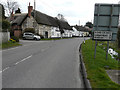
Looking south along Ludgershall Road (A346)
Collingbourne Ducis is a delightful village with many thatched cottages.
Image: © John Baker
Taken: 27 Mar 2015
0.04 miles
9
Milestone, Collingbourne Ducis
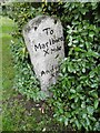
Carved stone post by the A338, in parish of Collingbourne Ducis (Kennet District), Ludgershall Road, opp. The Willows, just S of Blue Lion PH roundabout and Church Street jct, on wide grass area between road and stream, on West side of road. Marlborough gable erected by the Marlborough & Salisbury Turnpike Trust in the 18th century. Inscription reads: // To / Marlboro / X Miles / To / Andover / X Mile //. Grade II listed by Historic England: https://historicengland.org.uk/listing/the-list/list-entry/1035956. Milestone Society National ID: WI_MLAV10. From National Survey of Wayside Features by the Milestone Society https://www.milestonesociety.co.uk/.
Image: © Mike Faherty
Taken: 7 Oct 2019
0.05 miles
10
Collingbourne Ducis: Mill Lane
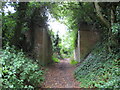
The brick walls on either side of Mill Lane here are the remaining abutments of the now dismantled bridge that carried the former Midland & South Western Junction Railway's main line between Andover and Swindon over the track. The railway was closed in 1961. The site of the former Collingbourne railway station was up on the embankment to the left. In a fit of enthusiasm I did clamber up the embankment to photograph the trackbed only to be confronted by a total wilderness of dense scrub, so you'll just have to imagine what it looks like!
Image: © Nigel Cox
Taken: 12 Jul 2009
0.06 miles