IMAGES TAKEN NEAR TO
Sunton, MARLBOROUGH, SN8 3DZ
Introduction
This page details the photographs taken nearby to Sunton, SN8 3DZ by members of the Geograph project.
The Geograph project started in 2005 with the aim of publishing, organising and preserving representative images for every square kilometre of Great Britain, Ireland and the Isle of Man.

There are currently over 7.5m images from over14,400 individuals and you can help contribute to the project by visiting https://www.geograph.org.uk
Image Map (Loading...)


Getting Data...Please wait
Leaflet Map data © OpenStreetMap
Images are licensed for reuse under creativecommons.org/licenses/by-sa/2.0
Notes
- Clicking on the map will re-center to the selected point.
- The higher the marker number, the further away the image location is from the centre of the postcode.
Image Listing (17 Images Found)
Images are licensed for reuse under creativecommons.org/licenses/by-sa/2.0
Image
Details
Distance
2
River through the fence
River Bourne where it runs through some gardens in Collingbourne Ducis, the bridge you can see links someone's garden.
Image: © Bill Nicholls
Taken: 20 Apr 2008
0.07 miles
3
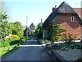
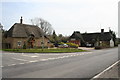
Sunton
Cottages in the northern part of Collingbourne Kingston.
Image: © Andrew Smith
Taken: 4 Nov 2006
0.13 miles
4
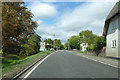
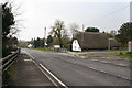
A338 High Street, Collingbourne Ducis
Looking north on the way out of the village.
Image: © Robin Webster
Taken: 16 Sep 2018
0.15 miles
5
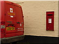
Collingbourne Ducis: postbox № SN8 42
This George VI-reign postbox is set into the wall of the post office and is emptied finally at 4:15pm on weekdays – it is about that time now and the post van is parked alongside; the postman will empty the box once he's collected from the post office counter. The Saturday collection time is 10am.
Image: © Chris Downer
Taken: 1 Jun 2010
0.15 miles
6
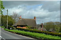
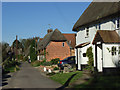
Thatched cottages beside the A338 at Sunton
Image: © David Martin
Taken: 25 Apr 2018
0.15 miles
7
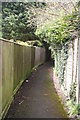
Alleyway to the school
Only found this alley when I saw some people come out of it and asked where it went.
Image: © Bill Nicholls
Taken: 20 Apr 2008
0.16 miles
8
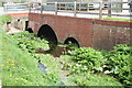
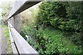
River under the road
Point where the river Bourne runs under the road near Sutton.
Image: © Bill Nicholls
Taken: 20 Apr 2008
0.18 miles
9
An Old pub
This was an old pub, but it is shown as Inn disused c.1888. The land next to the pub (where the new build cottage is) was shown as an orchard up until 1926. And open land after that. It was never a pub car park, as the pub (Inn) had shut down in the mid 19thC.
My thanks to Matthew Hatton for the info
Image: © Bill Nicholls
Taken: 20 Apr 2008
0.18 miles
10
Thatched cottages
Some of the thatched cottages in Collingbourne Ducis, the road on the right leads up to the school and the village hall.
Image: © Bill Nicholls
Taken: 20 Apr 2008
0.18 miles