IMAGES TAKEN NEAR TO
Wilton Road, MARLBOROUGH, SN8 3DJ
Introduction
This page details the photographs taken nearby to Wilton Road, SN8 3DJ by members of the Geograph project.
The Geograph project started in 2005 with the aim of publishing, organising and preserving representative images for every square kilometre of Great Britain, Ireland and the Isle of Man.

There are currently over 7.5m images from over14,400 individuals and you can help contribute to the project by visiting https://www.geograph.org.uk
Image Map
Images are licensed for reuse under creativecommons.org/licenses/by-sa/2.0
Notes
- Clicking on the map will re-center to the selected point.
- The higher the marker number, the further away the image location is from the centre of the postcode.
Image Listing (10 Images Found)
Images are licensed for reuse under creativecommons.org/licenses/by-sa/2.0
Image
Details
Distance
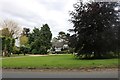
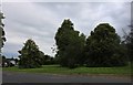
2
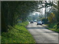
The road to East Grafton from Wilton, Wiltshire
East Grafton is an attractive village in the centre of Wiltshire. It straddles two squares, this one and the next one west.
Image: © Brian Robert Marshall
Taken: 15 Apr 2007
0.09 miles
3
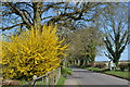
Spring colour on the edge of East Grafton
Image: © David Martin
Taken: 25 Mar 2019
0.12 miles
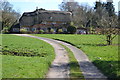
5
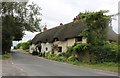
Thatched cottage on Grafton Road, East Grafton
Image: © David Howard
Taken: 8 Jul 2019
0.14 miles
6
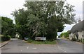
Wilton Road at the junction of Grafton Road
Image: © David Howard
Taken: 8 Jul 2019
0.14 miles
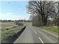
7
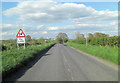
A338 south of Severalls
The alignment of this section of the road gives a distant view of the Wilton Windmill.
Image: © Stuart Logan
Taken: 16 May 2012
0.16 miles
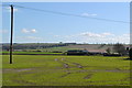
10
Track across the green at East Grafton
Image: © David Martin
Taken: 25 Mar 2019
0.24 miles