IMAGES TAKEN NEAR TO
West Grafton, MARLBOROUGH, SN8 3BY
Introduction
This page details the photographs taken nearby to SN8 3BY by members of the Geograph project.
The Geograph project started in 2005 with the aim of publishing, organising and preserving representative images for every square kilometre of Great Britain, Ireland and the Isle of Man.

There are currently over 7.5m images from over14,400 individuals and you can help contribute to the project by visiting https://www.geograph.org.uk
Image Map
Images are licensed for reuse under creativecommons.org/licenses/by-sa/2.0
Notes
- Clicking on the map will re-center to the selected point.
- The higher the marker number, the further away the image location is from the centre of the postcode.
Image Listing (9 Images Found)
Images are licensed for reuse under creativecommons.org/licenses/by-sa/2.0
Image
Details
Distance
1
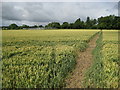
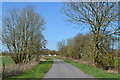
West Grafton: Footpath from East Grafton
West Grafton electricity sub-station is on the left.
Image: © Nigel Cox
Taken: 12 Jul 2009
0.09 miles
2
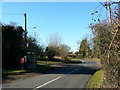
Postbox, phone box and bus stop, West Grafton, Wiltshire
Essential facilities all together in one convenient location.
Image: © Brian Robert Marshall
Taken: 3 Feb 2007
0.15 miles
3
West Grafton: Former M&SWJR main line railway
Up until closure in 1961 this was the track bed of the former Midland & South Western Junction Railway (M&SWJR) main line railway, viewed looking southwards towards the Andover end of the line. The route of the railway is in use as a main farm access track from this point southwards for several kilometres and is private land.
Image: © Nigel Cox
Taken: 12 Jul 2009
0.17 miles
4
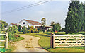
Former Grafton & Burbage station, 1994
View SE, towards Ludgershall - Andover Junction: ex-M&SWJR Cheltenham - Swindon Town - Marlborough - Andover Junction secondary main line. The station and line both closed completely (except Ludgershall - Andover Junction) from 11/9/61; the station has been converted to a very nice house and garden.
Image: © Ben Brooksbank
Taken: 1 Jun 1994
0.17 miles
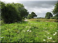
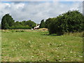
5
Farm track on former railway line, West Grafton
In the distance is the former station building, now a private house.
Image: © David Martin
Taken: 25 Mar 2019
0.18 miles
6

Oil-seed rape, West Grafton
Viewed from the dismantled Marlborough to Andover railway, which is now a track serving Manor Farm.
Image: © Andrew Smith
Taken: 29 Apr 2007
0.19 miles
7
West Grafton: Former Grafton and Burbage railway station
This a view taken looking up the former Midland & South Western Junction Railway's main line towards the former Grafton and Burbage railway station. Never the busiest of lines in terms of ordinary passenger trains, and even less busy at this station, by 1953 there were just 4 southbound trains that stopped here a day, and, by one of those oddities of railway timetables, only 3 northbound. The line closed in 1961 and the station is today a private residence. This was taken from the public footpath between East and West Grafton that crosses over the line.
Image: © Nigel Cox
Taken: 12 Jul 2009
0.19 miles
8
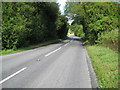
West Grafton: A338 Grafton Road and former M&SWJR crossing
Many motorists will drive along the A338 here between East and West Grafton unaware that a former main line railway crossed the road by means of a bridge here, the actual crossing point being somewhere in the trees in the distance. The former Midland & South Western Junction Railway (M&SWJR) double-tracked main line between Cheltenham and Andover was built in 1891 and closed in 1961.
Image: © Nigel Cox
Taken: 12 Jul 2009
0.19 miles
9
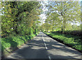
A338 north of Kingstone Farm
This is also known as Grafton Road.
Image: © Stuart Logan
Taken: 16 May 2012
0.22 miles