IMAGES TAKEN NEAR TO
Westcourt, Burbage, MARLBOROUGH, SN8 3BS
Introduction
This page details the photographs taken nearby to SN8 3BS by members of the Geograph project.
The Geograph project started in 2005 with the aim of publishing, organising and preserving representative images for every square kilometre of Great Britain, Ireland and the Isle of Man.

There are currently over 7.5m images from over14,400 individuals and you can help contribute to the project by visiting https://www.geograph.org.uk
Image Map (Loading...)


Getting Data...Please wait
Leaflet Map data © OpenStreetMap
Images are licensed for reuse under creativecommons.org/licenses/by-sa/2.0
Notes
- Clicking on the map will re-center to the selected point.
- The higher the marker number, the further away the image location is from the centre of the postcode.
Image Listing (8 Images Found)
Images are licensed for reuse under creativecommons.org/licenses/by-sa/2.0
Image
Details
Distance
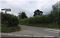
2
Cottage near Marr Green, Wiltshire
The property has been identified as Harepath Cottage, Westcourt, Burbage.
Image: © Brian Robert Marshall
Taken: 3 Feb 2007
0.07 miles
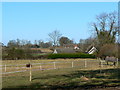
3
Burbage Road
By Harepath Farm on the left
Image: © David Howard
Taken: 8 Jul 2019
0.15 miles
5
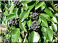
Black berries on a dead tree near Marr Green, Wiltshire
The plant is attached to what appears to be a dead oak tree. It has been identified courtesy of another contributor as an ivy plant Hedera helix. http://www.geograph.org.uk/discuss/index.php?&action=vthread&forum=2&topic=4888#4
Image: © Brian Robert Marshall
Taken: 3 Feb 2007
0.18 miles
6
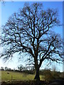
Tree on farm track near Marr Green, Wiltshire
The adjacent land starts rising to the left.
Image: © Brian Robert Marshall
Taken: 3 Feb 2007
0.18 miles
7
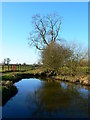
Tree and pond on farm track near Marr Green, Wiltshire
Clear blue skies over this rural scene.
Image: © Brian Robert Marshall
Taken: 3 Feb 2007
0.18 miles
8
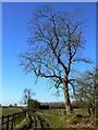
Farm track near Marr Green, Wiltshire
The track is not a right of way, which may explain why it has been blocked with road scalpings.
Image: © Brian Robert Marshall
Taken: 3 Feb 2007
0.20 miles