IMAGES TAKEN NEAR TO
Burbage Wharf, MARLBOROUGH, SN8 3BJ
Introduction
This page details the photographs taken nearby to Burbage Wharf, SN8 3BJ by members of the Geograph project.
The Geograph project started in 2005 with the aim of publishing, organising and preserving representative images for every square kilometre of Great Britain, Ireland and the Isle of Man.

There are currently over 7.5m images from over14,400 individuals and you can help contribute to the project by visiting https://www.geograph.org.uk
Image Map
Images are licensed for reuse under creativecommons.org/licenses/by-sa/2.0
Notes
- Clicking on the map will re-center to the selected point.
- The higher the marker number, the further away the image location is from the centre of the postcode.
Image Listing (49 Images Found)
Images are licensed for reuse under creativecommons.org/licenses/by-sa/2.0
Image
Details
Distance
1
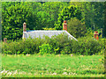
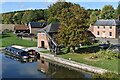
Burbage Wharf
Use of a zoom lens brings the roof and chimneys of some of the buildings that comprise the wharf into clearer view, even though the viewpoint is 400 metres away.
Image: © Brian Robert Marshall
Taken: 29 May 2009
0.01 miles
2
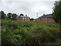
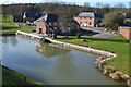
Burbage Wharf, from the south-west
The village of Burbage is about 2km south of the Kennet & Avon canal.
Image: © Christine Johnstone
Taken: 2 Oct 2013
0.02 miles
4
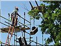
Dismantling Burbage Wharf Crane - 2007
Rotting timbers had made the crane unsafe. Here it is being dismantled prior to restoration.
More about Burbage: http://www.wiltshire.gov.uk/community/getcom2.php?id=41
Image: © Maurice Pullin
Taken: 2 Jun 2007
0.02 miles
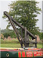
5
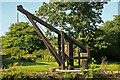
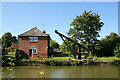
Burbage Wharf - wooden crane
This wharf on the Kennet & Avon Canal summit pound was constructed in 1831 by the Savernake estate. It handled local timber, stone, agricultural products and bricks. A timber fixed jib slewing crane handled cargoes. The canal ceased use in 1950 and the crane fell into disrepair. It was restored from 1973 to 1977 and then again in 2010 when it was largely renewed but using the original ironwork.
Image: © Chris Allen
Taken: 22 Jul 2012
0.03 miles
7
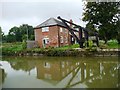
Burbage Wharf, from the south-east
Built for freight, now used for housing.
Image: © Christine Johnstone
Taken: 2 Oct 2013
0.03 miles
8
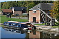
Narrowboats and restored crane at Burbage Wharf
Image: © David Martin
Taken: 16 Oct 2022
0.03 miles
9
Burbage Wharf, seen from the road bridge
This is such a photogenic spot - although the heavy traffic on the narrow road overbridge is rather at odds with the peaceful scene.
Image: © David Martin
Taken: 16 Oct 2022
0.03 miles
10
Kennet and Avon Canal - Burbage Wharf and crane
This wharf on the Kennet & Avon Canal summit pound was constructed in 1831 by the Savernake estate. It handled local timber, stone, agricultural products and bricks. A timber fixed jib slewing crane handled cargoes. The canal ceased use in 1950 and the crane fell into disrepair. It was restored from 1973 to 1977 and then again in 2010 when it was largely renewed but using the original ironwork.
Image: © Chris Allen
Taken: 22 Jul 2012
0.03 miles