IMAGES TAKEN NEAR TO
Lavington Close, MARLBOROUGH, SN8 3AL
Introduction
This page details the photographs taken nearby to Lavington Close, SN8 3AL by members of the Geograph project.
The Geograph project started in 2005 with the aim of publishing, organising and preserving representative images for every square kilometre of Great Britain, Ireland and the Isle of Man.

There are currently over 7.5m images from over14,400 individuals and you can help contribute to the project by visiting https://www.geograph.org.uk
Image Map (Loading...)


Getting Data...Please wait
Leaflet Map data © OpenStreetMap
Images are licensed for reuse under creativecommons.org/licenses/by-sa/2.0
Notes
- Clicking on the map will re-center to the selected point.
- The higher the marker number, the further away the image location is from the centre of the postcode.
Image Listing (51 Images Found)
Images are licensed for reuse under creativecommons.org/licenses/by-sa/2.0
Image
Details
Distance
1
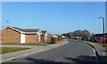
Suthmere Drive, Burbage
Burbage is an ancient village with a lot of new development since the mid 20th century.
Image: © Des Blenkinsopp
Taken: 27 Feb 2019
0.03 miles
2
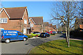
Martingale Road, Burbage
One of the newest roads in a village which is still expanding.
A free advert for S.T. Plastering is included.
Image: © Des Blenkinsopp
Taken: 27 Feb 2019
0.08 miles
3
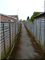
The Orange Way in Wiltshire (349)
This is a twitten between residences. The road at the end is in the next grid square to the north.
Image: © Shazz
Taken: 28 Apr 2013
0.08 miles
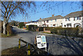
4
![Burbage houses [27]](https://s2.geograph.org.uk/geophotos/07/39/68/7396802_bb3f01a1_120x120.jpg)
Burbage houses [27]
Modern housing in Martingale Road.
Burbage is a village in the Vale of Pewsey, Wiltshire, it lies about 5½ miles southeast of Marlborough and some 15½ miles west of Newbury. The narrow village High Street was the main north to south road from Marlborough to Andover (A346) until a bypass was built to the west in 1991. Settlement can be traced back to the Neolithic period, and Bronze Age artefacts have been found. Burbage is now essentially a commuter village.
Image: © Michael Dibb
Taken: 23 Jan 2023
0.09 miles
5
![Burbage buildings [6]](https://s0.geograph.org.uk/geophotos/07/39/68/7396804_1a0d8ea5_120x120.jpg)
Burbage buildings [6]
The Royal British Legion Club in Eastcourt Road.
Burbage is a village in the Vale of Pewsey, Wiltshire, it lies about 5½ miles southeast of Marlborough and some 15½ miles west of Newbury. The narrow village High Street was the main north to south road from Marlborough to Andover (A346) until a bypass was built to the west in 1991. Settlement can be traced back to the Neolithic period, and Bronze Age artefacts have been found. Burbage is now essentially a commuter village.
Image: © Michael Dibb
Taken: 23 Jan 2023
0.10 miles
6
![Burbage buildings [7]](https://s2.geograph.org.uk/geophotos/07/39/68/7396806_622789ea_120x120.jpg)
Burbage buildings [7]
Burbage Village Hall in Eastcourt Street.
Burbage is a village in the Vale of Pewsey, Wiltshire, it lies about 5½ miles southeast of Marlborough and some 15½ miles west of Newbury. The narrow village High Street was the main north to south road from Marlborough to Andover (A346) until a bypass was built to the west in 1991. Settlement can be traced back to the Neolithic period, and Bronze Age artefacts have been found. Burbage is now essentially a commuter village.
Image: © Michael Dibb
Taken: 23 Jan 2023
0.11 miles
7
Outside the Village Hall
Eastcourt Road, Burbage
Image: © Des Blenkinsopp
Taken: 27 Feb 2019
0.13 miles
8
![Burbage features [7]](https://s2.geograph.org.uk/geophotos/07/40/05/7400510_8ece6932_120x120.jpg)
Burbage features [7]
Barn Meadow Recreation Ground, seen from Eastcourt Road.
Burbage is a village in the Vale of Pewsey, Wiltshire, it lies about 5½ miles southeast of Marlborough and some 15½ miles west of Newbury. The narrow village High Street was the main north to south road from Marlborough to Andover (A346) until a bypass was built to the west in 1991. Settlement can be traced back to the Neolithic period, and Bronze Age artefacts have been found. Burbage is now essentially a commuter village.
Image: © Michael Dibb
Taken: 23 Jan 2023
0.14 miles
9
![Burbage houses [25]](https://s3.geograph.org.uk/geophotos/07/39/67/7396795_84661f9b_120x120.jpg)
Burbage houses [25]
Numbers 218 and 220 High Street are two 17th century cottages. Timber framed, much of which has been replaced in rendered brick, all under a thatch roof. No 220 has a tiled single storey link to a weatherboarded and thatched outbuilding to the rear. Listed, grade II, with details at: https://historicengland.org.uk/listing/the-list/list-entry/1194517
Burbage is a village in the Vale of Pewsey, Wiltshire, it lies about 5½ miles southeast of Marlborough and some 15½ miles west of Newbury. The narrow village High Street was the main north to south road from Marlborough to Andover (A346) until a bypass was built to the west in 1991. Settlement can be traced back to the Neolithic period, and Bronze Age artefacts have been found. Burbage is now essentially a commuter village.
Image: © Michael Dibb
Taken: 23 Jan 2023
0.15 miles
10
![Burbage houses [24]](https://s1.geograph.org.uk/geophotos/07/39/67/7396793_8fbdb88c_120x120.jpg)
Burbage houses [24]
This late 17th or early 18th century house is now two cottages, Cobweb Cottage, number 212 High Street and Spiders, number 214 High Street. Constructed of diaper brick under a thatch roof. Number 212 is earlier and set gable end to the street. Number 214 has a late 20th century extension at the rear and a lean-to porch. Listed, grade II, with details at: https://historicengland.org.uk/listing/the-list/list-entry/1035925
Burbage is a village in the Vale of Pewsey, Wiltshire, it lies about 5½ miles southeast of Marlborough and some 15½ miles west of Newbury. The narrow village High Street was the main north to south road from Marlborough to Andover (A346) until a bypass was built to the west in 1991. Settlement can be traced back to the Neolithic period, and Bronze Age artefacts have been found. Burbage is now essentially a commuter village.
Image: © Michael Dibb
Taken: 23 Jan 2023
0.15 miles