IMAGES TAKEN NEAR TO
High Street, MARLBOROUGH, SN8 3AF
Introduction
This page details the photographs taken nearby to High Street, SN8 3AF by members of the Geograph project.
The Geograph project started in 2005 with the aim of publishing, organising and preserving representative images for every square kilometre of Great Britain, Ireland and the Isle of Man.

There are currently over 7.5m images from over14,400 individuals and you can help contribute to the project by visiting https://www.geograph.org.uk
Image Map
Images are licensed for reuse under creativecommons.org/licenses/by-sa/2.0
Notes
- Clicking on the map will re-center to the selected point.
- The higher the marker number, the further away the image location is from the centre of the postcode.
Image Listing (22 Images Found)
Images are licensed for reuse under creativecommons.org/licenses/by-sa/2.0
Image
Details
Distance
1
![Burbage houses [5]](https://s0.geograph.org.uk/geophotos/07/39/38/7393824_cd12d05a_120x120.jpg)
Burbage houses [5]
Meadowview Cottage, number 54 High Street, was built in the early or mid 18th century. Constructed of painted brick under a thatch roof. There is an extension at the rear. Listed, grade II, with details at: https://historicengland.org.uk/listing/the-list/list-entry/1035919
Burbage is a village in the Vale of Pewsey, Wiltshire, it lies about 5½ miles southeast of Marlborough and some 15½ miles west of Newbury. The narrow village High Street was the main north to south road from Marlborough to Andover (A346) until a bypass was built to the west in 1991. Settlement can be traced back to the Neolithic period, and Bronze Age artefacts have been found. Burbage is now essentially a commuter village.
Image: © Michael Dibb
Taken: 23 Jan 2023
0.05 miles
2
![Burbage houses [6]](https://s1.geograph.org.uk/geophotos/07/39/38/7393825_21f03a5a_120x120.jpg)
Burbage houses [6]
Number 57 High Street and Angel Cottage, number 59 High Street, are a pair of 18th century cottages. Constructed of diaper brick under a thatch roof. Both cottages have one bay, each extended by a narrow lean-to bay at the end. There are dates of 1777 and 1781 scratched on the brickwork. Listed, grade II, with details at: https://historicengland.org.uk/listing/the-list/list-entry/1035913
Burbage is a village in the Vale of Pewsey, Wiltshire, it lies about 5½ miles southeast of Marlborough and some 15½ miles west of Newbury. The narrow village High Street was the main north to south road from Marlborough to Andover (A346) until a bypass was built to the west in 1991. Settlement can be traced back to the Neolithic period, and Bronze Age artefacts have been found. Burbage is now essentially a commuter village.
Image: © Michael Dibb
Taken: 23 Jan 2023
0.09 miles
3
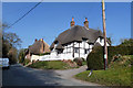
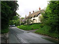
Thatched cottages, Burbage
Both buildings are grade II listed, the near cottage 17th century, the far pair 18th century.
Image: © Robin Webster
Taken: 20 Mar 2015
0.10 miles
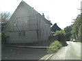
4
Cottages and Traffic, Burbage
Burbage High Street wasn't designed for some of the trucks that come through here.
Image: © Des Blenkinsopp
Taken: 27 Feb 2019
0.10 miles
5
![Burbage houses [7]](https://s2.geograph.org.uk/geophotos/07/39/38/7393826_5c044aab_120x120.jpg)
Burbage houses [7]
Number 61 High Street is a 17th century cottage. Built on a brick sill, timber framed with wattle and daub infill, under a thatch roof. The framing is 3 panels high with wavy corner braces. There is a rear extension to the right. Some original internal features remain. The cottage was renovated in the late 1980s. Listed, grade II, with details at: https://historicengland.org.uk/listing/the-list/list-entry/1194435
Burbage is a village in the Vale of Pewsey, Wiltshire, it lies about 5½ miles southeast of Marlborough and some 15½ miles west of Newbury. The narrow village High Street was the main north to south road from Marlborough to Andover (A346) until a bypass was built to the west in 1991. Settlement can be traced back to the Neolithic period, and Bronze Age artefacts have been found. Burbage is now essentially a commuter village.
Image: © Michael Dibb
Taken: 23 Jan 2023
0.10 miles
7
High Street, Burbage
This is the northern part of the High street where the cottages well sit above road level.
Image: © Stuart Logan
Taken: 29 Sep 2011
0.10 miles
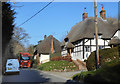
8
Thatched cottages, Burbage
Looking north along High Street from the junction with Smithy Lane.
Image: © Simon Mortimer
Taken: 5 Aug 2012
0.12 miles
9
![Burbage houses [8]](https://s2.geograph.org.uk/geophotos/07/39/38/7393830_c1ccdfc2_120x120.jpg)
Burbage houses [8]
Numbers 63 and 65 High Street are two attached cottages. Probably built in the 16th century, they have been greatly altered. Timber framed, rendered, under a thatch roof. There is a rear extension to number 63. The cottages are believed to contain cruck construction. Listed, grade II, with details at: https://historicengland.org.uk/listing/the-list/list-entry/1035914
Burbage is a village in the Vale of Pewsey, Wiltshire, it lies about 5½ miles southeast of Marlborough and some 15½ miles west of Newbury. The narrow village High Street was the main north to south road from Marlborough to Andover (A346) until a bypass was built to the west in 1991. Settlement can be traced back to the Neolithic period, and Bronze Age artefacts have been found. Burbage is now essentially a commuter village.
Image: © Michael Dibb
Taken: 23 Jan 2023
0.12 miles
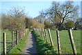
10
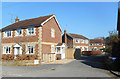
The Withies, Stibb Green
A short residential cul de sac off the High Street.
Image: © Des Blenkinsopp
Taken: 27 Feb 2019
0.12 miles