IMAGES TAKEN NEAR TO
Dando Drive, MARLBOROUGH, SN8 1TT
Introduction
This page details the photographs taken nearby to Dando Drive, SN8 1TT by members of the Geograph project.
The Geograph project started in 2005 with the aim of publishing, organising and preserving representative images for every square kilometre of Great Britain, Ireland and the Isle of Man.

There are currently over 7.5m images from over14,400 individuals and you can help contribute to the project by visiting https://www.geograph.org.uk
Image Map (19 Images)


Getting Data...Please wait
Leaflet Map data © OpenStreetMap
Images are licensed for reuse under creativecommons.org/licenses/by-sa/2.0
Notes
- Clicking on the map will re-center to the selected point.
- The higher the marker number, the further away the image location is from the centre of the postcode.
Image Listing (19 Images Found)
Images are licensed for reuse under creativecommons.org/licenses/by-sa/2.0
Image
Details
Distance
1
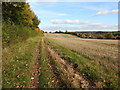
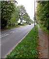
Bridleway approaching Marlborough
Bridleway at the edge of a harvested cornfield, heading for Barton Dene west of Marlborough.
Image: © Vieve Forward
Taken: 20 Oct 2015
0.12 miles
2
![Marlborough houses [29]](https://s1.geograph.org.uk/geophotos/06/41/67/6416773_85bcdda5_120x120.jpg)
Marlborough houses [29]
Upcot Cottage is the former lodge to Upcot. Built in 1886 and listed, grade II, with details at: https://historicengland.org.uk/listing/the-list/list-entry/1034271
Marlborough is a market town on the Old Bath Road once the main road from London to Bath. The twice-weekly market is sited in High Street, one of the widest in England, lined on both sides with fine listed buildings of which the town has almost 300. There is evidence of local settlement from every period from the prehistoric to the present day. The town is home to the renowned Marlborough College. The River Kennet flows through the town.
Image: © Michael Dibb
Taken: 9 Mar 2020
0.12 miles
3
![Marlborough houses [30]](https://s3.geograph.org.uk/geophotos/06/41/67/6416779_360370fe_120x120.jpg)
Marlborough houses [30]
Upcot was built for Marlborough College in 1886 as a master's house with a boy's dormitory at the rear. Additions were made in 1928 in the same style and materials. Listed, grade II, with details at: https://historicengland.org.uk/listing/the-list/list-entry/1252937
Marlborough is a market town on the Old Bath Road once the main road from London to Bath. The twice-weekly market is sited in High Street, one of the widest in England, lined on both sides with fine listed buildings of which the town has almost 300. There is evidence of local settlement from every period from the prehistoric to the present day. The town is home to the renowned Marlborough College. The River Kennet flows through the town.
Image: © Michael Dibb
Taken: 9 Mar 2020
0.13 miles
4
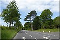
Mature trees at junction of Golding Avenue and A4
Image: © David Smith
Taken: 1 Jun 2017
0.14 miles
7
West along Bath Road between Marlborough and Manton
The A4 Bath Road approaches a sign on the left showing the way to Manton and Barton Park.
Image: © Jaggery
Taken: 14 Oct 2017
0.17 miles
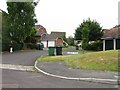
8
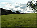
Houses and playing field at College Fields, Marlborough
Image: © Rob Purvis
Taken: 11 Oct 2009
0.20 miles
9
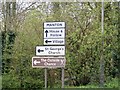
The way to Manton
From Bath Road, A4, the sign points the way to Manton. The Outside Chance is a local public House see Image
Image: © Michael Dibb
Taken: 28 Mar 2017
0.22 miles
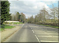
10
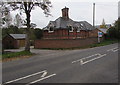
East Lodge, Bath Road, Marlborough
Viewed across the A4 Bath Road.
Image: © Jaggery
Taken: 14 Oct 2017
0.22 miles