IMAGES TAKEN NEAR TO
The Parade, MARLBOROUGH, SN8 1NY
Introduction
This page details the photographs taken nearby to The Parade, SN8 1NY by members of the Geograph project.
The Geograph project started in 2005 with the aim of publishing, organising and preserving representative images for every square kilometre of Great Britain, Ireland and the Isle of Man.

There are currently over 7.5m images from over14,400 individuals and you can help contribute to the project by visiting https://www.geograph.org.uk
Image Map
Images are licensed for reuse under creativecommons.org/licenses/by-sa/2.0
Notes
- Clicking on the map will re-center to the selected point.
- The higher the marker number, the further away the image location is from the centre of the postcode.
Image Listing (722 Images Found)
Images are licensed for reuse under creativecommons.org/licenses/by-sa/2.0
Image
Details
Distance
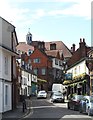
1
View down "The Parade", Marlborough
This is taken from the alley at the back of the old Town Hall,
and is looking down a road called "The Parade".
Image: © mike smith
Taken: 15 Sep 2008
0.02 miles
2
Derelict building in The Parade, Marlborough
Viewed in October 2017. The derelict building is next door to Faux Arts Studio at 30 The Parade.
Image: © Jaggery
Taken: 14 Oct 2017
0.02 miles
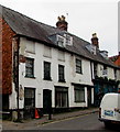
3
![Marlborough buildings [62]](https://s3.geograph.org.uk/geophotos/06/99/12/6991239_175b7bc7_120x120.jpg)
Marlborough buildings [62]
Numbers 28 to 30 The Parade are a row of three early 18th century houses, now shops. Number 28 (furthest from the camera) is partly timber framed, the other two possibly are. Otherwise rendered brick under a slate roof. Listed, grade II, with details at: https://historicengland.org.uk/listing/the-list/list-entry/1273043
Marlborough is a market town on the Old Bath Road once the main road from London to Bath. The twice-weekly market is sited in High Street, one of the widest in England, lined on both sides with fine listed buildings of which the town has almost 300. There is evidence of local settlement from every period from the prehistoric to the present day. The town is home to the renowned Marlborough College. The River Kennet flows through the town.
Image: © Michael Dibb
Taken: 11 Jun 2021
0.02 miles
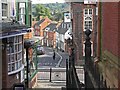
4
South-east to The Parade, Marlborough
The viewpoint was provided by pedestrian steps up from Oxford Street to Kingsbury Street. The Parade curves away into the distance. There are several pubs and restaurants in the immediate vicinity.
Image: © Brian Robert Marshall
Taken: 7 Jul 2011
0.02 miles
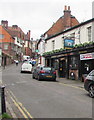
5
Urban scene, Marlborough
The top end of The Parade in Marlborough, where for those with a thirst, there's a choice of three pubs. The high roof in the background is that of the Town Hall.
Image: © Gordon Hatton
Taken: 22 May 2017
0.02 miles
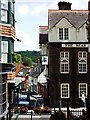
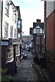
6
Up The Parade, Marlborough
The Parade ascends towards Oxford Street past the Lamb Inn. http://www.geograph.org.uk/photo/5568836 to the Lamb name sign.
Image: © Jaggery
Taken: 14 Oct 2017
0.02 miles
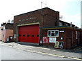
7
Perrins Hill, Marlborough
Alley behind the Town Hall
Image: © John Myers
Taken: 17 Jan 2020
0.02 miles
8
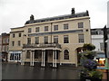
Ailesbury Court, Marlborough
This is now a block of flats
Image: © David Howard
Taken: 21 Aug 2016
0.02 miles
9
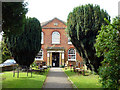
Marlborough - Converted Chapel
This converted chapel was built in 1817 and rebuilt in 1873, but is now an antique centre.
Image: © Chris Talbot
Taken: 30 Aug 2008
0.02 miles