
IMAGES TAKEN NEAR TO
Figgins Lane, High Street, MARLBOROUGH, SN8 1NA
Introduction
This page details the photographs taken nearby to Figgins Lane, High Street, SN8 1NA by members of the Geograph project.
The Geograph project started in 2005 with the aim of publishing, organising and preserving representative images for every square kilometre of Great Britain, Ireland and the Isle of Man.

There are currently over 7.5m images from over14,400 individuals and you can help contribute to the project by visiting https://www.geograph.org.uk
Image Map
Images are licensed for reuse under creativecommons.org/licenses/by-sa/2.0
Notes
- Clicking on the map will re-center to the selected point.
- The higher the marker number, the further away the image location is from the centre of the postcode.
Image Listing (729 Images Found)
Images are licensed for reuse under creativecommons.org/licenses/by-sa/2.0
Image
Details
Distance
1
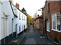
Figgins Lane, Marlborough
Another narrow thoroughfare that leads away from the High Street, I couldn't find out much about it other than that the local council (Kennet District Council) regards it as a 'locally important employment location'. This image looks towards the south-east from just off the High Street.
Image: © Brian Robert Marshall
Taken: 9 Nov 2007
0.01 miles
2
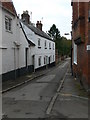
Figgins Lane, Marlborough
A lane going from the High Street down to the river.
Image: © Eirian Evans
Taken: 22 Oct 2010
0.01 miles
3
![Marlborough houses [2]](https://s0.geograph.org.uk/geophotos/05/49/17/5491780_8b8a2997_120x120.jpg)
Marlborough houses [2]
The narrow lane is part of a public footpath which connects George Lane with High Street.
Marlborough is a market town on the Old Bath Road once the main road from London to Bath. The twice-weekly market is sited in High Street, one of the widest in England, lined on both sides with fine listed buildings of which the town has almost 300. There is evidence of local settlement from every period from the prehistoric to the present day. The town is home to the renowned Marlborough College. The River Kennet flows through the town.
Image: © Michael Dibb
Taken: 17 Jul 2017
0.01 miles
4
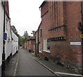
Figgins Lane, Marlborough
Looking to the SE from High Street along Figgins Lane, not a through route for vehicles.
Image: © Jaggery
Taken: 14 Oct 2017
0.01 miles
5
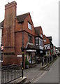
Fair Isle shop, High Street, Marlborough
The shop on the corner of Figgins Lane sells wool, haberdashery and childrenswear.
Image: © Jaggery
Taken: 14 Oct 2017
0.01 miles
6
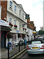
Marlborough - The Merlin Hotel
The Merlin Hotel in Marlborough's High Street.
Image: © Chris Talbot
Taken: 30 Aug 2008
0.01 miles
7
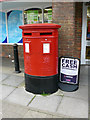
Marlborough - Double Postbox
Quite a rare sight in this part of the country.
Image: © Chris Talbot
Taken: 30 Aug 2008
0.01 miles
8
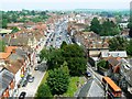
High Street, Marlborough from St Peter's church roof
Looking north-east up the Georgian High Street. A slightly patronising view of the historic town can be seen in this 1969 BBC documentary http://news.bbc.co.uk/local/wiltshire/hi/people_and_places/arts_and_culture/newsid_8342000/8342839.stm
Image: © Brian Robert Marshall
Taken: 9 Jun 2007
0.02 miles
9
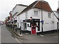
Downtown Marlborough
Downtown Barbers shop is at 39 High Street Marlborough, on the corner of Figgins Lane.
Image: © Jaggery
Taken: 14 Oct 2017
0.02 miles
10

Figgins Lane
An old route off the High Street, which used to run past the old White Friars Priory. However, in its modern form the lane now crosses the Kennet and continues on the other bank.
Image: © Neil Owen
Taken: 1 Jul 2025
0.02 miles