IMAGES TAKEN NEAR TO
Portfields Road, SN8 1EY
Introduction
This page details the photographs taken nearby to Portfields Road, SN8 1EY by members of the Geograph project.
The Geograph project started in 2005 with the aim of publishing, organising and preserving representative images for every square kilometre of Great Britain, Ireland and the Isle of Man.

There are currently over 7.5m images from over14,400 individuals and you can help contribute to the project by visiting https://www.geograph.org.uk
Image Map
Images are licensed for reuse under creativecommons.org/licenses/by-sa/2.0
Notes
- Clicking on the map will re-center to the selected point.
- The higher the marker number, the further away the image location is from the centre of the postcode.
Image Listing (10 Images Found)
Images are licensed for reuse under creativecommons.org/licenses/by-sa/2.0
Image
Details
Distance
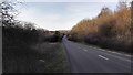
1
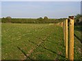
Meadows, Marlborough
A fence under construction beside the byway. The former Chiseldon and Marlborough railway is in the trees to the left.
Image: © Andrew Smith
Taken: 21 Apr 2007
0.16 miles
2
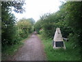
Resting place along the Marlborough and Chiseldon railway path, looking north
Image: © Rob Purvis
Taken: 10 Jul 2011
0.16 miles
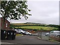
4
![Marlborough features [12]](https://s3.geograph.org.uk/geophotos/05/46/78/5467807_35528b09_120x120.jpg)
Marlborough features [12]
Seen from the footpath is the dam or pond bay of the ‘King’s Bay Mead’ or ‘Great Bay’ fishpond constructed in 1204 to produce fish for the Royal Manor of Marlborough. A Scheduled Ancient Monument there is much detail and history at: https://www.historicengland.org.uk/listing/the-list/list-entry/1005644
Marlborough is a market town on the Old Bath Road once the main road from London to Bath. The twice-weekly market is sited in High Street, one of the widest in England, lined on both sides with fine listed buildings of which the town has almost 300. There is evidence of local settlement from every period from the prehistoric to the present day. The town is home to the renowned Marlborough College. The River Kennet flows through the town.
Image: © Michael Dibb
Taken: 17 Jul 2017
0.18 miles
5
![Marlborough ways [20]](https://s0.geograph.org.uk/geophotos/05/46/79/5467900_ab3bb669_120x120.jpg)
Marlborough ways [20]
The footpath heads towards the wonderfully named street of Tin Pit.
Marlborough is a market town on the Old Bath Road once the main road from London to Bath. The twice-weekly market is sited in High Street, one of the widest in England, lined on both sides with fine listed buildings of which the town has almost 300. There is evidence of local settlement from every period from the prehistoric to the present day. The town is home to the renowned Marlborough College. The River Kennet flows through the town.
Image: © Michael Dibb
Taken: 17 Jul 2017
0.19 miles
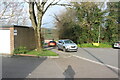
6
![Marlborough ways [17]](https://s1.geograph.org.uk/geophotos/05/46/78/5467801_3d113a8e_120x120.jpg)
Marlborough ways [17]
The footpath leaves North View Place and descends steeply.
Marlborough is a market town on the Old Bath Road once the main road from London to Bath. The twice-weekly market is sited in High Street, one of the widest in England, lined on both sides with fine listed buildings of which the town has almost 300. There is evidence of local settlement from every period from the prehistoric to the present day. The town is home to the renowned Marlborough College. The River Kennet flows through the town.
Image: © Michael Dibb
Taken: 17 Jul 2017
0.19 miles
7
![Marlborough houses [12]](https://s1.geograph.org.uk/geophotos/05/46/77/5467797_ad58a581_120x120.jpg)
Marlborough houses [12]
Marlborough has many beautiful buildings. Unfortunately there is a lot of unattractive and bland houses such as these in Baylie Acre.
Marlborough is a market town on the Old Bath Road once the main road from London to Bath. The twice-weekly market is sited in High Street, one of the widest in England, lined on both sides with fine listed buildings of which the town has almost 300. There is evidence of local settlement from every period from the prehistoric to the present day. The town is home to the renowned Marlborough College. The River Kennet flows through the town.
Image: © Michael Dibb
Taken: 17 Jul 2017
0.22 miles
10
![Marlborough ways [21]](https://s3.geograph.org.uk/geophotos/05/46/79/5467903_17bde391_120x120.jpg)
Marlborough ways [21]
The footpath arrives at the wonderfully named street of Tin Pit. So named because of a (now disused) quarry.
Marlborough is a market town on the Old Bath Road once the main road from London to Bath. The twice-weekly market is sited in High Street, one of the widest in England, lined on both sides with fine listed buildings of which the town has almost 300. There is evidence of local settlement from every period from the prehistoric to the present day. The town is home to the renowned Marlborough College. The River Kennet flows through the town.
Image: © Michael Dibb
Taken: 17 Jul 2017
0.24 miles