IMAGES TAKEN NEAR TO
Laggots Close, FARINGDON, SN7 8RY
Introduction
This page details the photographs taken nearby to Laggots Close, SN7 8RY by members of the Geograph project.
The Geograph project started in 2005 with the aim of publishing, organising and preserving representative images for every square kilometre of Great Britain, Ireland and the Isle of Man.

There are currently over 7.5m images from over14,400 individuals and you can help contribute to the project by visiting https://www.geograph.org.uk
Image Map
Images are licensed for reuse under creativecommons.org/licenses/by-sa/2.0
Notes
- Clicking on the map will re-center to the selected point.
- The higher the marker number, the further away the image location is from the centre of the postcode.
Image Listing (15 Images Found)
Images are licensed for reuse under creativecommons.org/licenses/by-sa/2.0
Image
Details
Distance
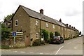
3
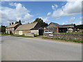
Farmhouse on High Street, Hinton Waldrist
Image: © David Howard
Taken: 5 Feb 2023
0.04 miles
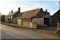
4
Laggott's Farm, High Street
This was formerly the blacksmith's shop, having been identified as such from stereo photographs dating from the 1850s in 'A Village Lost and Found' by Brian May and Elena Vidal.
Image: © Vieve Forward
Taken: 15 Aug 2019
0.04 miles
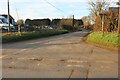
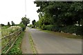
6
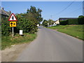
Approaching Hinton Waldrist from Longworth
Image: © andrew auger
Taken: 13 Oct 2008
0.12 miles
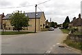
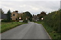
8
High Street Hinton Waldrist
From Manor Farm High Street Hinton Waldrist
Image: © Shaun Ferguson
Taken: 5 Sep 2012
0.17 miles
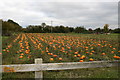
9
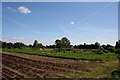
Across the allotment
Quite a large allotment for a village this size.
Image: © Bill Nicholls
Taken: 23 Aug 2009
0.20 miles