IMAGES TAKEN NEAR TO
Buckland, FARINGDON, SN7 8RG
Introduction
This page details the photographs taken nearby to SN7 8RG by members of the Geograph project.
The Geograph project started in 2005 with the aim of publishing, organising and preserving representative images for every square kilometre of Great Britain, Ireland and the Isle of Man.

There are currently over 7.5m images from over14,400 individuals and you can help contribute to the project by visiting https://www.geograph.org.uk
Image Map
Images are licensed for reuse under creativecommons.org/licenses/by-sa/2.0
Notes
- Clicking on the map will re-center to the selected point.
- The higher the marker number, the further away the image location is from the centre of the postcode.
Image Listing (5 Images Found)
Images are licensed for reuse under creativecommons.org/licenses/by-sa/2.0
Image
Details
Distance
1
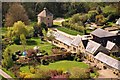
Home Farm, Buckland Warren
Showing distinctive octagonal Pigeon House
Image: © Dave Price
Taken: 6 May 2013
0.02 miles
2
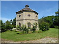
Dovecote, Home Farm
Grade II* Listed dovecote, built c.1755. https://britishlistedbuildings.co.uk/101048686-home-farm-dovecote-buckland#.XR-nMmeWyUk
Image: © Vieve Forward
Taken: 4 Jul 2019
0.05 miles
3
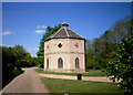
Old Pigeon House at Home Farm
The door to this, round the other side, was open as we walked past.
Without being too nosey, it looked like the inside has been converted into accommodation, albeit rather dark with the windows bricked up.
Image: © Des Blenkinsopp
Taken: 2 May 2011
0.06 miles
4

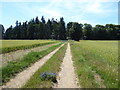
Blue Tractor
Parked on the corner of this large open field by Home Farm
Image: © Des Blenkinsopp
Taken: 2 May 2011
0.11 miles