IMAGES TAKEN NEAR TO
Pusey, FARINGDON, SN7 8QE
Introduction
This page details the photographs taken nearby to SN7 8QE by members of the Geograph project.
The Geograph project started in 2005 with the aim of publishing, organising and preserving representative images for every square kilometre of Great Britain, Ireland and the Isle of Man.

There are currently over 7.5m images from over14,400 individuals and you can help contribute to the project by visiting https://www.geograph.org.uk
Image Map
Images are licensed for reuse under creativecommons.org/licenses/by-sa/2.0
Notes
- Clicking on the map will re-center to the selected point.
- The higher the marker number, the further away the image location is from the centre of the postcode.
Image Listing (2 Images Found)
Images are licensed for reuse under creativecommons.org/licenses/by-sa/2.0
Image
Details
Distance
1
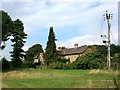
Bushy Cottages, Pusey
A couple of isolated farm dwellings on the southern edge of this square.
Image: © Des Blenkinsopp
Taken: 2 Sep 2014
0.01 miles
2
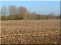
Farmland, Pusey
A field of stubble beside the bridleway to the east of the village.
Image: © Andrew Smith
Taken: 14 Jan 2012
0.22 miles